Introduction to Geographic Information Systems in Forest Resources
| Introduction to Geographic Information Systems in Forest Resources |
|
|||||||||||||||
|
|||||||||||||||
Relational Databases
Types of Tables in ArcGIS
Tabular Operations in ArcGIS
Relational Database Management Systems (RDBMS)
Tables
Almost all of the tabular data used in a GIS are stored in relational database tables. Although a full treatment of the topic of relational databases goes beyond the scope of this course, we will at least need a brief introduction.
Outside of a GIS, tabular data are commonly held and manipulated in relational databases such as dBASE, rBase, ACCESS, Oracle, SQLServer, INFORMIX, or other high-end relational database management systems (RDBMS). The tables in these databases are often linked with inter-tabular relationships, hence the name "relational" database.
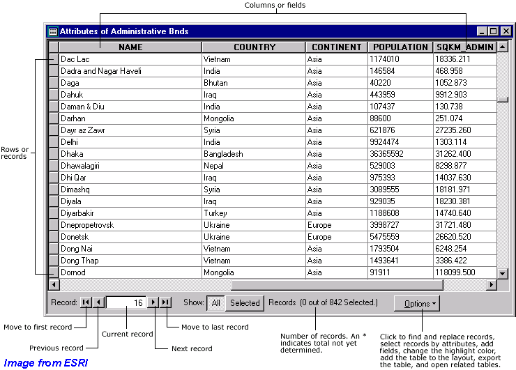
Tables are composed of columns or fields, and rows or records. These terms can be interchanged.
Requests for selections, or subsets, of tables are known as "queries." A typical query uses syntax equivalent to
select all records from the airport points table whose value for airport name contains the word "INTL"
ArcGIS has a graphical user interface for performing queries on tables, so that you do not need to learn any complicated special query languages, such as SQL. Although ArcGIS table selections do use a particular syntax, we will cover the syntax later in the module on tables.
Associations between tables
Central to the relational database model is the idea of linkages between tables. In ArcGIS, these are known as relates and links. Common values for common items are used to associate records from one table to another. This image (from Excel) is an example of how tables are structured, and how relates can be made between tables:
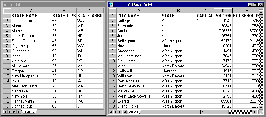
In the states.dbf table, fields exist for the attributes representing state name, FIPS (Federal Information Processing Standard) zone, and state name abbreviation. A single record exists for each state.
In the cities.dbf table, fields exist for the attributes representing city name, state, etc., and there is a single record for each city.
If the values for a particular field in one table match the values in a particular field in the other table, a relationship can be made between the tables. Because both tables contain the field representing the state name, and the fields appear to be defined in the same manner (simple text), it should be possible to relate or join the tables based on the common value of the state name field. In this way, it is possible to make selections on one table that also select related records in the other table, or to combine the tables into a single virtual table. We could select the single record representing the state of Washington in the states.dbf table and have an automatic selection of all records from the cities.dbf table representing cities within Washington state.
We will work in depth with joining and linking tables later in Creating and Modifying Tables.
For each layer in ArcGIS (except for floating-point grids, discussed later), an attribute table exists. The table stores feature geometry type (point, line, polygon, etc.), as well as any other user-defined attributes. Anything you want to store as information about features can be stored in the layer attribute table. Feature measurements (coordinate location, length, and area) can also be calculated and stored as feature attributes.
Raster grids with integer values also have attribute tables, but the relationship is not one-to-one, cell-to-record, but on a zone-by-zone basis. A grid value attribute table is essentially a frequency table, where each unique value (zone) has a record enumerating the number of cells within that zone. Zones will be discussed later in Raster Analysis.
Please note that most of the data you will encounter will have been built within ArcInfo. The attribute tables for ArcInfo are structured differently from other attribute tables, but the functional differences are only slight.
Tables can also exist within the GIS that have no relationship to geospatial data layers. You may have freestanding tables that represent habitat codes for land cover polygons, ID numbers and nest statistics for breeding pairs of birds, or phone numbers and addresses of a group of surveyed households.
File formats
Several data source file formats can be used to create tables in ArcGIS :
- relational database tables stored in a personal geodatabase
- dBASE files
- tab- or comma-delimited plain text (ASCII) files
- INFO database tables (from ArcInfo)
ArcGIS can also create tables from ODBC and SDE geodatabase connections. These tables appear the same in ArcGIS, but behave slightly different from file-based tables.
Although a full treatment will come later in the course, here is a brief introduction to a few important tabular operations available in ArcGIS.
Joins
Joins are performed to append the contents of one table to another. It is necessary for the tables to share a common field, such as an ID number for a breeding pair, a stand name, or a state FIPS code.
When 2 tables are joined in ArcGIS, one table becomes appended onto the other as a single virtual table.
Joins are only temporary. Joins do not physically append the system files which hold the tabular data. Each joined table still exists on its own.
Relates
Relates are similar to joins, but the tables that are related are not appended to one another. Instead, when a selection is made in one of 2 related tables, any related items in the other table are also selected. Like joins, relates are only active within ArcGIS, and they do not change the state of the files on the disk drive.
Displaying Tabular Data in a Spatial Context
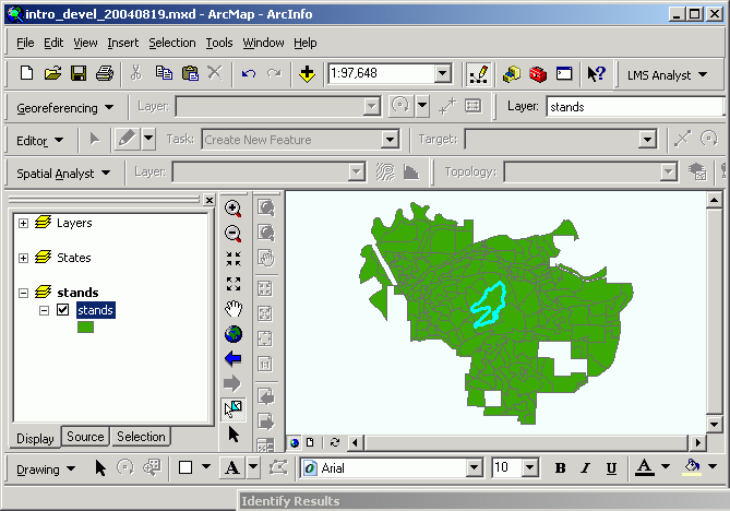
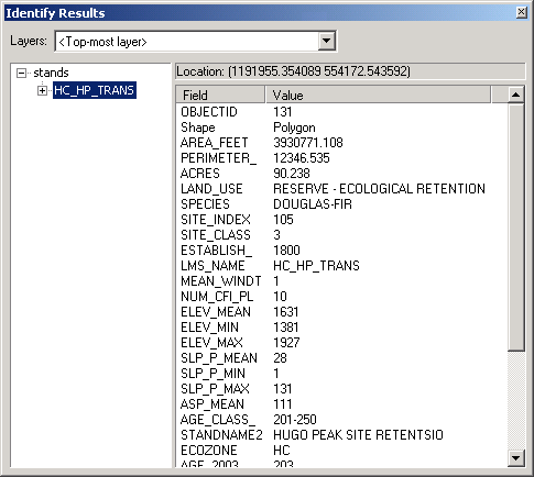
Because tabular and spatial data are coincident within a spatial data layer, it is possible to make selections on spatial features and then view the attribute records for those features. Here, a single stand is selected from the map display, and its tabular attributes are viewed.
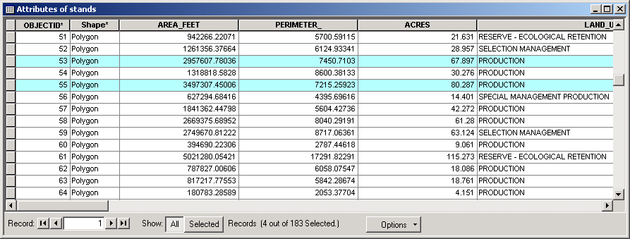
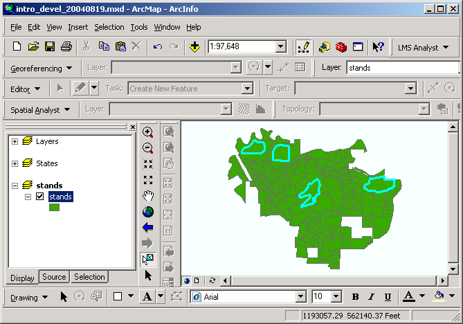
Likewise, it is possible to select records from a layer's attribute table, and have associated spatial features highlighted within the geographic view window. Here, a group of records from the Stands table is selected, and the associated polygons are automatically highlighted. This is standard behavior for layers and their associated tables in ArcGIS
In this manner, you can either find out properties of features based on their location, or select features based on their properties, and then see where the features are arranged spatially.
Return to top | ahead to Scale Issues
|
|||||||||||||||

|
The University of Washington Spatial Technology, GIS, and Remote Sensing Page is supported by the School of Forest Resources |
School of Forest Resources |