Introduction to Geographic Information Systems in Forest Resources
| Introduction to Geographic Information Systems in Forest Resources |
|
|||||||||||||||
|
|||||||||||||||
Blank CDs are available at any computer or office store, and are fairly inexpensive at the University Bookstore.
ISO Image
You will use this zipped ISO image of the course CD (esrm250.zip, ~240 MB) to create your copy. You will need a CD writer accompanied by software than can handle an ISO image. DO NOT write the zip file or the ISO file to the CD. You must use software that will create a CD with the proper file structure from an ISO image. If you have any doubts about what you are doing, ask the lab staff where you are making the image, or you risk wasting time and blank CDs. You can also open the help files for the CD writing software and search for ISO.
Under most circumstances, you will have no trouble downloading the zip file, unzipping, and creating the CD. After you download the esrm250_aut2004.zip archive, you will need to unzip it. If it does not unzip properly, you will need to download again. After you unzip the file, you should have two files (esrm250_aut2004.iso and esrm250_aut2004.iso.md5sum).
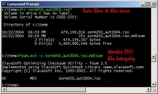
You can check the integrity of the downloaded file by using md5sum or fsum. If you want to make sure the file you downloaded and unzipped is not corrupt, follow this sequence. On a Windows machine, download fsum.exe. Use a command prompt, following the sequence shown below (assuming you have downloaded and unzipped the archive and have fsum.exe in C:\temp). Green text is what you will type. Red text explains what the commands do.
Making a CD
Most modern (i.e., less than a few years old) computers will have CD writers as standard equipment. Many facilities around campus have computers you can use to create CDs. Here is a limited list:
Tips:
CD Structure
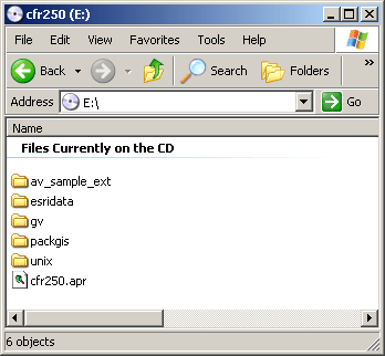
There are a number of directories and files on the CD.
Data files are in the directories packgis (Pack Forest data) and esridata (general datasets from ESRI).
Sample ArcView 3.x extensions are in the directory av_sample_ext.
Various UNIX-style utilities are in the directory unix. These include tools for managing zip and archive files as well as a large number of other utilities.
Ghostscript/Ghostview are in the gv directory. These will allow you to create PDF files even if you do not have access to Adobe Acrobat Writer.
The contents of the CD should look like this:
Most of the datasets used are from the Pack Forest GIS Database.
Where not otherwise specified, the data are in this Projection/Coordinate system:
Projection STATEPLANE
Zone 5626 (Washington State, South Zone)
Datum HPGN*
Units FEET
Spheroid GRS1980* HPGN is also known as NAD83/91, but is similar to NAD83 for most purposes.
When asked for measurements, etc., it will be assumed that you are using the State Plane data, and that the storage and measurement units are feet, unless otherwise specified. However, you will need to explicitly provide units for reported values.
Any datasets ending with other names (e.g., bound_utm) will have Projection/Coordinate systems signified by the file name.
|
|||||||||||||||

|
The University of Washington Spatial Technology, GIS, and Remote Sensing Page is supported by the School of Forest Resources |
School of Forest Resources |