Introduction to Geographic Information Systems in Forest Resources
| Introduction to Geographic Information Systems in Forest Resources |
|
|||||||||||||||
|
|||||||||||||||
Projections and coordinate systems are a complicated topic in GIS, but they form the basis for how a GIS can store, analyze, and display spatial data. Understanding projections and coordinate systems important knowledge to have, especially if you deal with many different sets of data that come from different sources.
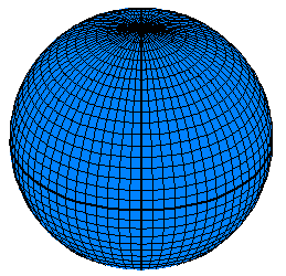
The best model of the earth would be a 3-dimensional solid in the same shape as the earth. Spherical globes are often used for this purpose. However, globes have several drawbacks.
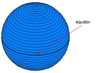
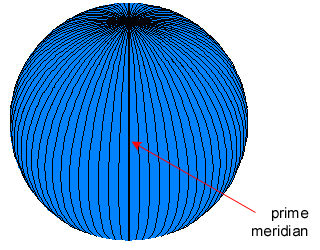
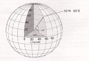
Here is an image of a globe, displaying lines of reference. These lines can only be used for measurement of angles on a sphere. They cannot be used for making linear or areal measurements.
 |
 |
 |
|
|
|
|
Positions on a globe are measured by angles rather than X, Y (Cartesian planar) coordinates. In the image below, the specific point on the surface of the earth is specified by the coordinate (60 °. E longitude, 55 den. N latitude). The longitude is measured as the number of degrees from the prime meridian, and the latitude is measured as the number of degrees from the equator.
[Image from ESRI]
For this reason, projection systems have been developed. Map projections are sets of mathematical models which transform spherical coordinates (such as latitude and longitude) to planar coordinates (x and y). In the process, data which actually lie on a sphere are projected onto a flat plane or a surface. That surface can be converted to a planar section without stretching.
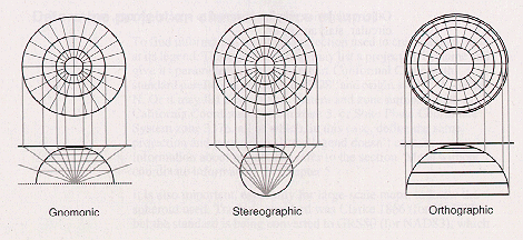
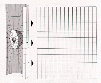
Here is a simple schematic designed to show how a projection works. Imagine a glass sphere marked with grid lines or geographic features. A light positioned in the center of the sphere shines ("projects") outward, casting shadows from the lines. A plane, cone, or cylinder (known as a developable surface) is placed outside the sphere. Shadows are cast upon the surface. The surface is opened flat, and the geographic features are displayed on a flat plane. As soon as a projection is applied, a Cartesian coordinate system (regular measurement in X and Y dimensions) is implied. The user gets to choose the details of the coordinate system (e.g., units, origin, and offsets).
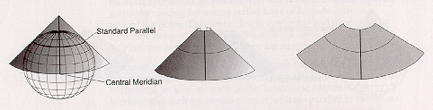
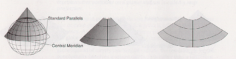
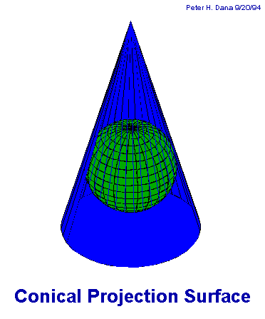
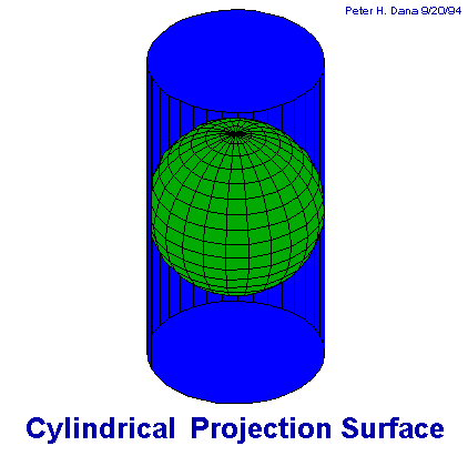
The projection surfaces (i.e., cylinders, cones, and planes) form the basic types of projections:
| Conic |
|
The conic tangent case:
Standard parallels are where the cone touches or slices through the
globe. Conic projections are used frequently for mapping large areas (e.g., states, large countries, or continents). |
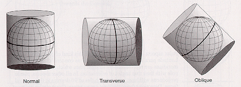
| Cylindrical |
|
Different cylindrical projection orientations:
The most common cylindrical projection is the Mercator projection, which is the basis of the UTM (Universal Transverse Mercator) system. |
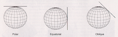
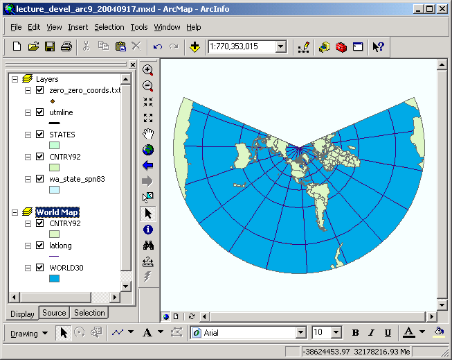
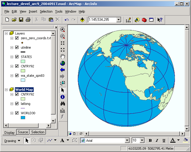
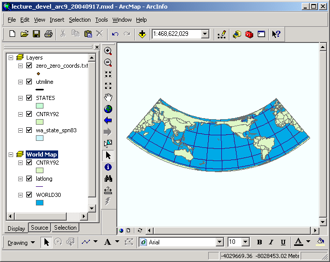
| Planar (Orthographic) |
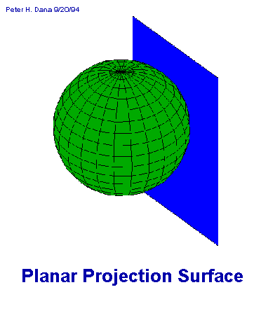
|
Different orthographic projection parameters:
|
Notice in these images how distortion in distance is minimized at the place on the surface that is closest to the sphere. Distortion increases as you travel along the surface farther from the light source. This distortion is an unavoidable property of map projection. Although many different map projections exist, they all introduce distortion in one or more of the following measurement properties:
Distortion will vary in at least one of each of the above properties depending on the projection used, as well as the scale of the map, or the spatial extent that is mapped. Whenever one type of distortion is minimized, there will be corresponding increases in the distortion of one or more of the other properties.
There are names for the different classes of projections that minimize distortion.
It is appropriate to choose a projection based on which measurement properties are most important to your work. For example, if it is very important to obtain accurate area measurements (e.g., for determining the home range of an animal species), you will select an equal-area projection.
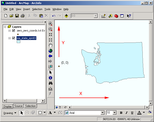
Once map data are projected onto a planar surface, features must be referenced by a planar coordinate system. The geographic system (latitude-longitude), which is based on angles measured on a sphere, is not valid for measurements on a plane. Therefore, a Cartesian coordinate system is used, where the origin (0, 0) is toward the lower left of the planar section. The true origin point (0, 0) may or may not be in the proximity of the map data you are using.
Coordinates in the GIS are measured from the origin point. However, false eastings and false northings are frequently used, which effectively offset the origin to a different place on the coordinate plane. This is done in order to achieve several purposes:
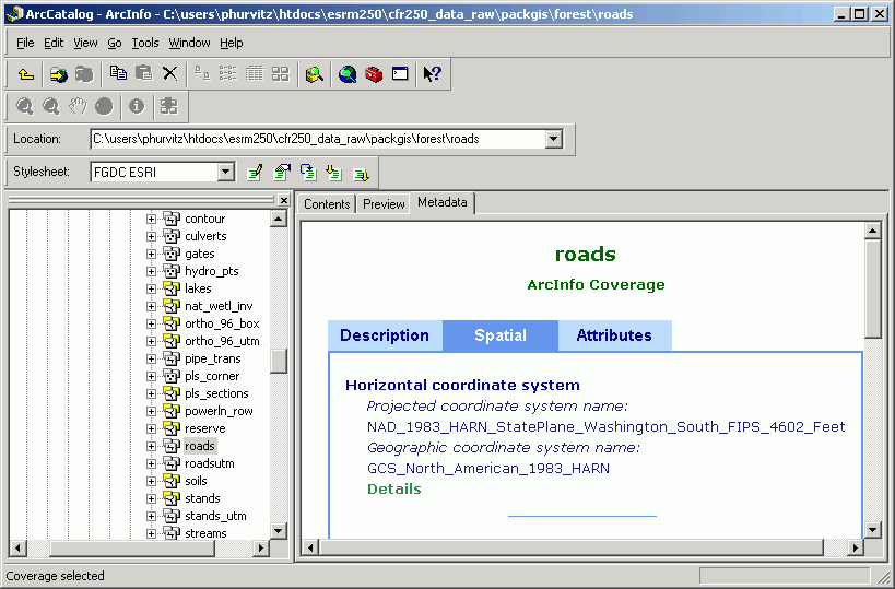
In this image, Washington state is projected to State Plane North (NAD83). All of the locations on the map are now referenced in Cartesian coordinates, where the origin lies several hundred miles off the Pacific coast.
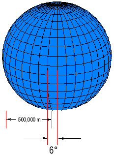
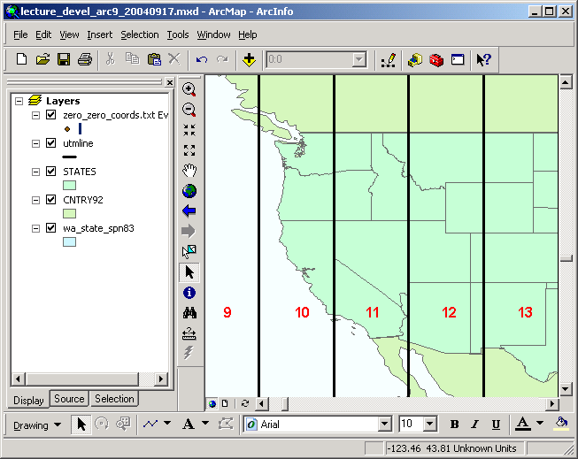
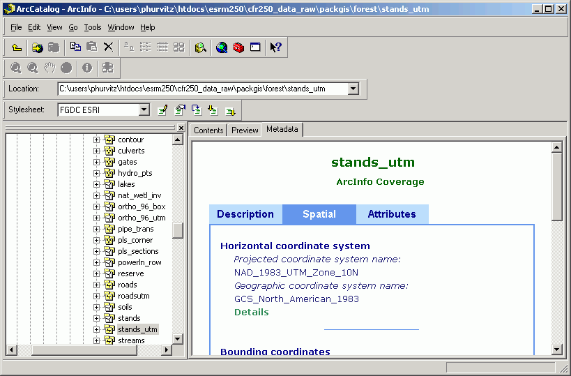
Some measurement framework systems define both projections and coordinate systems. For example, the Universal Transverse Mercator (UTM) system, commonly used by scientists and Federal organizations, is based on a series of 60 transverse Mercator projections, in which different areas of the earth fall into different 6-degree zones. Within each zone, a local coordinate system is defined, in which the X-origin is located 500,000 m west of the central meridian, and the Y-origin is the south pole or the equator, depending on the hemisphere. The State Plane system also defines both projection and coordinate system.
The two most common coordinate/projection systems you will encounter in the USA are:
| Zone |
SPCS Zone # |
FIPS Zone # |
Projection |
1st Std. Parallel |
2nd Std. Parallel |
Central Meridian |
Origin |
False Easting |
False Northing |
| WA_N |
5601 |
4601 |
Lambert Conformal Conic |
47 30 00 |
48 44 00 |
-120 50 00 |
47 00 00 |
609601.21920 |
0 |
| WA_S |
5626 |
4602 |
Lambert Conformal Conic |
45 50 00 |
47 20 00 |
-120 30 00 |
45 20 00 |
609601.21920 |
0 |

Datums are sets of parameters and ground control points defining local coordinate systems. Because the earth is not a perfect sphere, but is somewhat "egg-shaped," geodesists use spheroids and ellipsoids to model the 3-dimensional shape of the earth. Although the earth can be modeled by an egg-shaped solid, local variations still exist, due to differential thickness of the earth's crust, or differential gravitation due to density of the crustal material. A datum is created to account for these local variations in establishing a coordinate system.
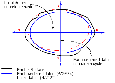
image from ESRI
In the image above, the earth is shown as the irregular surface (thick black line). A generalized earth-centered coordinate system (WGS84, in blue) provides a good overall mean solution for all places on the earth. However, for specific local measurements, WGS84 cannot account for local variations. Instead, local datums have been developed. In this example, the local North American Datum of 1927 (NAD27, in dashed red line) more closely fits the earth's surface in the upper-left quadrant of the earth's cross-section. NAD27 only fits this quadrant, so to use it in another part of the earth will result in serious errors in measurement. For mapping North America, in order to obtain the most accurate locations and measurements, NAD27 or NAD83/91 are used.
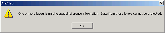
All spatial datasets are stored with one projection/coordinate system or another. Even the so-called "unprojected" datasets, which have their coordinates stored in decimal degrees of latitude and longitude, are using a spatial reference system that is managed by the computer. This is what is meant by "storage." Every dataset is stored with a spatial reference, regardless of if the spatial referencing system is documented with the dataset.
If a dataset has been built with documentation about its spatial referencing, then it is said to have a projection or coordinate system "defined." If a dataset has no projection defined, it is possible to use the software to define the projection, that is, to add extra data that describe the projection and coordinate system of the dataset.
In any case, it is extremely important, as a user, to know the projection and coordinate system of all the data you use. Sometimes datasets will appear to be incompatible; if this happens, sometimes the only step necessary to allow the datasets to be used together is to define the projection. Once the projection is defined, ArcGIS will be able to manage the datasets and, if necessary, project one of the datasets on the fly to match the other.
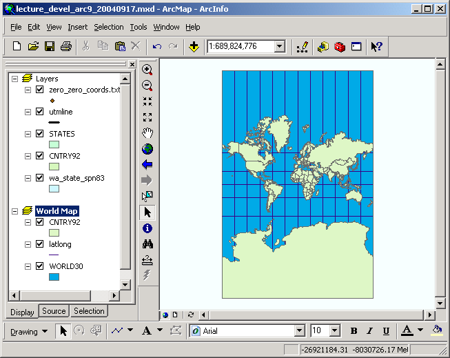
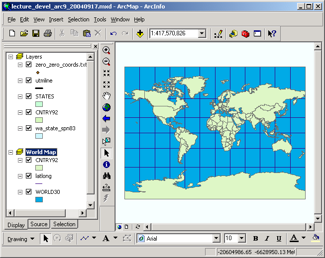
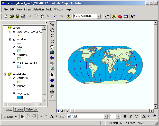
Here is a view of the world in several different projections, along with brief descriptions of their properties (descriptions copied from the on-line documentation):
| Mercator (cylindrical) |
Properties Shape: Conformal. Small shapes are well represented because this projection
maintains the local angular relationships. |
| Miller (cylindrical) |
Properties Shape: Minimally distorted between 45th parallels, increasingly toward
the poles. Land masses are stretched more east to west than they are north
to south. |
| Robinson (pseudo- cylindrical) |
Properties Shape: Shape distortion is very low within 45° of the origin and
along the Equator. |
| Lambert (planar) |
Properties Shape: Shape is minimally distorted, less than 2 percent, within 15°
from the focal point. Beyond that, angular distortion is more significant;
small shapes are compressed radially from the center and elongated perpendicularly. |
| Mollweide |
Properties Shape: Shape is not distorted at the intersection of the central meridian
and latitudes 40° 44' N and S. Distortion increases outward from these
points and becomes severe at the edges of the projection. |
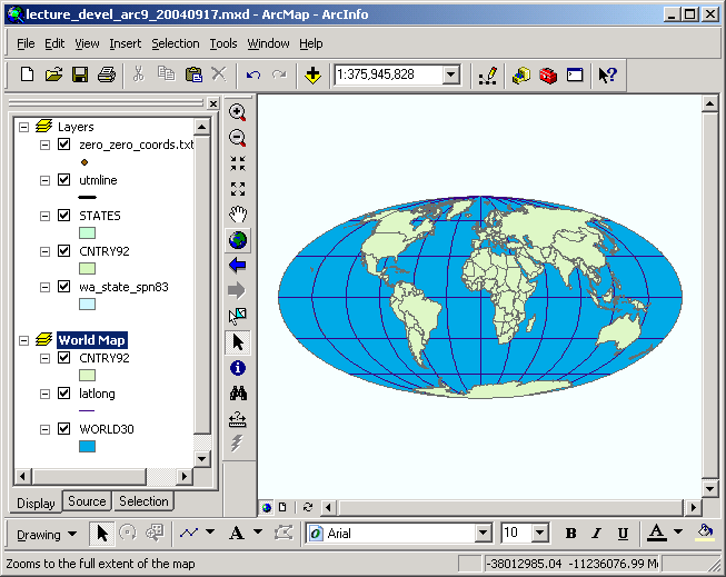
| Orthographic |
Properties Shape: Minimal distortion near the center; maximal distortion near the
edge. |
| Albers (conic) |
Properties Shape: Shape is true along the standard parallels of the normal aspect
(Type 1), or the standard lines of the transverse and oblique aspects
(Types 2 and 3). Distortion is severe near the poles of the normal aspect
or 90° from the central line in the transverse and oblique aspects. |
For more complete discussions of map projections and related topics, see these resources, or perform a web search:
Projecting spatial datasets
ArcGIS at version 9 supports projection transformations of both vector and raster data.
You may have data that are stored unprojected (i.e., the data have internal coordinates representing latitude and longitude measurements); other data may be stored in a projection/coordinate system such as State Plane or UTM. There are several possible options for projection transformations, based on how your data are stored:
ArcGIS will always attempt to project the view of data on the fly. A data frame's properties can be changed to match any supported projection/coordinate system. In this case, new datasets are not created, but only the view is changed. You can think of this as putting on different pairs of glasses, each one of which is a different projection. When you "view" unprojected or State Plane data with the UTM "glasses," your data will appear to be projected to UTM. If you view unprojected or UTM data with the State Plane "glasses," your data will appear to be projected to State Plane. However, you have not actually changed the data in any way, you have only changed the way you are looking at the data. When unprojected data are displayed in a view, they are by default shown in a display that appears similar to the Plate Carée projection.
If you are only displaying data together, it is fine to mix datasets that are stored with different projection parameters. However, if you are doing any analytical work, it is always suggested to make sure your datasets are stored in the same projection.
Also, it is always recommended to make sure your datasets have projections defined. That way, if there is any confusion, either for the developer or another user, one can always view the projection information.
A number of these situations will be covered in lab session.
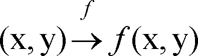
Each different projection is a mathematical function that takes coordinate pairs as inputs [(x, y)], and generates new coordinate pairs as output [f(x, y)], as shown in the generic function below. The projection function is symbolized by f.
| input |
output |
| angles |
Cartesian coordinates |
| State Plane |
UTM |
| Miller Cylindrical |
Lambert Azimuthal |
Here is an example of how a projection changes a set of coordinates. The original longitude/latitude coordinate is somewhere within Seattle.
| Projection, zone, datum (units) |
X |
Y |
| geographic, NAD27 (decimal degrees) |
-122.35° |
47.62° |
| UTM, Zone 10, NAD27 (meters) |
548843.5049 |
5274052.0957 |
| State Plane, WA-N, NAD83 (feet) |
1266092.5471 |
229783.3093 |
Each of the projections in this example (UTM, State Plane), are governed by a different set of projection functions, and therefore result in different output values from the same input value.
If you consider the vector data model, every point has a coordinate; every line's nodes and vertices have coordinates; and every polygon's outlines have coordinates. Projection of a dataset from one system to another is simply the process of applying the projection function to each coordinate in the dataset. The larger and more complex a dataset, the longer it will take to perform the projection.
You should be aware of a key difference between projecting a dataset and simply applying a projection to a data frame. In the former case, each pair of input coordinates has a new output coordinate location calculated. In the latter case, some generalization of data is used in order to speed display. When accurate and precise measurements are needed, always project the datasets themselves, rather than just projecting the data frame.
Return to top | Ahead to Help Topics
|
|||||||||||||||

|
The University of Washington Spatial Technology, GIS, and Remote Sensing Page is supported by the School of Forest Resources |
School of Forest Resources |