Site Report #4: The Past and Future

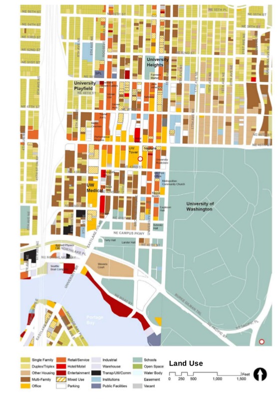
Birds eye view of U-District land use from the “University District Urban Design Framework”. Seattle Department of Planning and Development. June 2012.
The neighborhood in which my block is located is currently experiencing much of the rapid change that has defined this recent era of the University District. Like most of the area around it, my block’s neighborhood is a diverse mix of residential housing, office space, stores, and other commercial buildings. Looking specifically at my block and the adjacent streets and buildings, a few features are readily apparent. The first being the prominence of the UW Tower, currently the tallest building in the University District and the second the major construction underway on the section of Brooklyn Ave to the east of the tower. The construction of a new station on the light rail here is a clear example of the changing nature of the U-District and a sign of the overall growth of the area. Connecting the the heart of the U-District with the rest of Seattle through reliable transportation paves the way for the establishment of new businesses and residents that now have quick transportation from urban center to urban center.
In the “U District Green Streets Concept Plan” the Seattle Department of Planning and Development in conjunction with The Seattle Department of Transportation have laid out some of their plans for the future of the “green streets” of the University District. Some of the features of the concept plan are directly related to the area surrounding my block, namely, the designation the area between NE 43rd and NE 45th Streets as the “core” of Brooklyn Ave and transforming Brooklyn Ave into a “festival street”. (UDGSCP 15) The two departments hope to do this by significantly widening the sidewalks on this section of the street to “accommodate periodic community events”. (UDGSCP 17) I thought that this was a relevant idea since historically the District has been home to protests and celebrations so this space would be useful for those activities. Because Brooklyn Ave is not a transit corridor it is uniquely suited to hosting periodic community events and with the construction of the new link station the area is poised to become a community hub.
The “University District Urban Design Framework” takes another look at what brought the University District to this point in time and the direction that planning of the area will go in the future. This report was strongly grounded in the history of the U-District with a short historical summary and comparison shots of the U-District from the 30s to 2012. The report also included statistics on proportions of demographics like the of means of transportation. These kinds of statistics help give the planners a better picture of how people move through the district, giving them data to support changes in layout of the U-District. (UDUDF 19) The report also delves into the new changes in zoning, and the problems that arise from lack of housing. This lack of housing, especially affordable housing, is an important issue for University of Washington students. The report suggests that by diversifying the types of housing available, the area around the light rail station could create more opportunities for various types of living accommodations. (UDUDF 23)
Looking to the future, it is clear that city wants this block to be a center for community in the U-District. (as evidenced by the distinction as a “festival street”) While the University of Washington has not publically supported this plan, the school's policy to support the community suggests that they would be open to this type of conversion. (And they will certainly benefit from the light rail station) These types of change, from restructuring of city streets to the rezoning of growing communities, reflect change that is currently happening in other economically successful cities around the world. Seattle is another example of a city flourishing due to the economic success of companies located there. (i.e. tech companies) (O’Mara 2)
Works Cited
The Department of Planning. University District Urban Design Framework: Existing Conditions Report. N.p., n.d. Jun. 2012.
O’Mara, Margaret. "The Other Tech Bubble." The American Prospect. The American Prospect, 19 Feb. 2016. Web. 16 Mar. 2017.
"SDOT - Steep Streets in Seattle." SDOT - Steep Streets in Seattle. N.p., n.d. Web. 16 Mar. 2017.
Seattle Department of Planning and Development, Seattle Department of Transportation. U District Green Streets Concept Plan. Jan. 2015.
"University District to get First ‘Skyscraper’." Seattle Municipal News 14 Sep. 1928, Vol. XV, No. 47 ed.: n. pag. Print.
"Why UW Purchased Safeco Tower." Why UW Purchased Safeco Tower. N.p., n.d. Web. 16 Mar. 2017.
