|
|
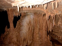
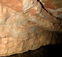
iCAVE was a pilot project undertaken in 2005 by Dr. Moskal's Remote Sensing and Geospatial Analysis Laboratory (RSGAL), while at Missouri State University, to show how various geospatial sciences, techniques and technologies can be utilized for the animation, visualization and exploration of caves in the Ozarks. The project partners included the James River Basin Watershed, in Springfield, MO. In 2009 the UW Geospatial Club partnered with students in archeology to use a terrestial LiDAR to map a cave comples in WA state. |
| Scientific Research |
- to determine the watershed areas for Ozarks caves using topographic\hydrologic data and digital elevation models (DEM); specifically the high resolution DEM's from the NASA Shuttle Radar Topographic Mission (SRTM)
- to study land use/land cover (LULC) changes within the watershed areas of Ozarks caves using remotely sensed imagery, including historic aerial photography and satellite imagery
- to integrate LULC change within the watershed areas of Ozarks caves with water quality data in a geospatial information system for watershed management
|
| Technology, Outreach and Education |
- to explore the potential techniques required to effectively photograph Ozarks caves and to produce interactive internet based tours of the caves
- to produce 3D imagery of the caves for potential application in 3D visualization and display systems
- to explore the potential of Photogrammetry methods and image feature extraction methods digital represent the structures in the caves
- to explore the utilization of Geographic Information Systems (GIS) to produce 3D maps of the caves that integrate other geospatial data such as topographic maps, aerial photography, satellite imagery
|
 .. ..  |
|
|
