Climate
Little over half the region, particularly the northern and eastern sector, is characterized by rainy or semi-rainy and cold climates and the rest of the lake area is semi-arid cold, with temperatures around the lake averaging at -10 to 23ˇC.
Annual rainfall varies more than fifty percent from its annual mean, while the range is from 200mm in the southern area to 1400mm in the northern area. The lake area experiences a dry season primarily between May and August and in turn, experiences a wet season from December to March.
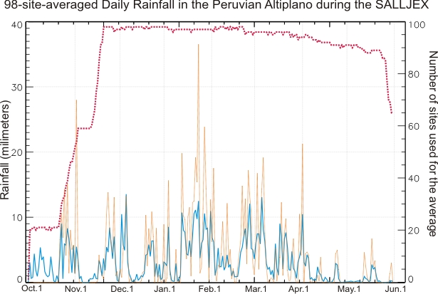
Data from SALLJEX RAINFALL ANALYSIS, http://www.nssl.noaa.gov/projects/pacs/web/ALTIPLANO/rainanalyses.html
This graph shows data from 98 stations around Lake Titicaca from October of 2002 to May of 2003. It catalogs the daily rainfall on the Peruvian Altiplano. The continuous blue line represents the daily rainfall averaged over all the reporting raingauges. The number of raingauges used for the average is indicated with a dotted red line.
Topography
The Altiplano is still undergoing tectonic activity and the area has many faults and the mountains still have some volcanic activity. While the majority of the area's topography is the result of ongoing tectonics, more recent changes to the landscape have been the result of the recent (in geological terms) glacial periods that provided the lake with more melt-off and rainfall.
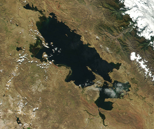
Most of the topography has been formed through the recent glacial periods, resulting in the rivers and smaller lakes around being larger during some times and smaller during others. Lake Titicaca's size has changed greatly during those times. At its largest, the lake was 50,000 square kilometers in comparison to its current size of 8,300 square kilometers.
Due to the high altitude and low temperatures, much of the soils around Lake Titicaca and the Altiplano lack nitrogen or organic material. Much of the area erosion is a result of past and present farming and graving activities.
Local Geography
Lake Titicaca itself lays on the flat area of the Altiplano and this has a dramatic affect on the shoreline and local agriculture. A simple change of a meter in the lake's levels can either flood or expose around 120,000 ha (hectacre) of land. Most of the local human settlement lays in this risk area. (Erickson)
The wetlands and areas along the shores are known as the pampa. These grassland plains are prone to the flooding mentioned earlier. The locals use the grasslands for grazing for their livestock.
The Cerro are the main farming lands for the locals where crops such as potatoes, maize, and quinoa are grown. This is where many of the terraced fields are and these lands are less prone to flooding. Due to the active farming, there is no natural vegetation in this area.
Finally there is the puna, cold, high-altitude grasslands located just below the glacial fields of the Andes. The puna around Lake Titicaca is known as humid puna due to the area's average 800 to 1200mm average annual rainfall. While the area appears to be uncultivated, locals have learned to grow cold-resistant potatoes on this climate region. The natural vegetation of the area is mainly grasses.
|