Hylebos Watershed Spring 2003
Results
The water temperatures within the watershed ranged from 9.0°C to 14°C. This range is well within healthy limits established by the EPA (2002) and those reported in Murdoch et al. (2001). See Table 2 for all water temperature data collected at each site. All sites, with the exception of the Kitts Corner Retention Pond Outflow site, had pH levels that also fell well within EPA (2002) limits and the limits reported in Murdoch et al. (2001), ranging from 6.46 - 7.80 (excluding Kitts Corner Retention Pond Outflow). It appears that some factor, most likely anthropogenic in nature, may be causing lower pH conditions at the Kitts Corner Retention Pond outflow, of which the recorded pH of 5.89 is below the reported EPA (2002) range of 6.5 - 8.56. See Table 2 for all pH data collected at each site.
Figure 1
.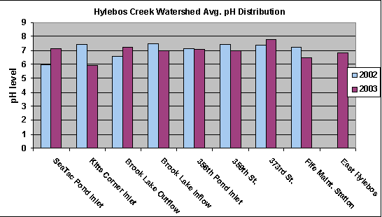
Each site was tested for levels of pH, to determine the watershed's acidic or basic pH levels. Measuring the pH level in water bodies is an important factor for determining aquatic life. If a solution has a pH value less than 7, it is considered acidic. Solutions with a pH value more than 7 are basic. Optimal range for most life is pH 6.5 - 8.2 (Murdock et al 2001). Graph I. displays variations in pH levels at each site location, for 2002 and 2003. According to graph 1, the results indicate a slight variation in last year's pH levels; yet prove to be at optimal levels within the Hylebos Creek Watershed. However, if urbanization continues, in or around the watershed, the increase/decrease in pH levels will have damaging effects on the watershed. Monitoring and reducing human actions will help keep the Hylebos Creek Watershed at an optimal pH level.
Figure 2.
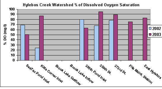
Almost all plants and animals need oxygen for growth and survival. Oxygen is present in water in a dissolved form. Streams with high dissolved oxygen concentrations (>8 mg/l) and 90-100% saturated are considered to be healthy systems (Murdoch et al 2001). Graph 2. shows the 2002-2003 dissolved oxygen % saturation for the Hylebos Creek Watershed. The dissolved oxygen concentrations ranged between 7-11 mg/l, with the exception of Kitts Corner outlet. Kitts Corner is a retention pond separate from Hylebos Creek and is not a concern at this time. Levels of dissolved oxygen saturation above 45% are safe for most fish and aquatic life (Kegley and Andrews 1998). At all of our locations, dissolved oxygen saturation levels were within a healthy range.
Dissolved oxygen levels were all within acceptable ranges, with the exception of those recorded at the Sea-Tac Mall and the outflow to Brook Lake (5.70 and 5.97 mg/L respectively)(EPA 2002). The depressed oxygen levels at the Sea-Tac mall facility may be the result of culverting. At Brook Lake, a drop of 3.1 mg/L in dissolved oxygen was observed from the inflow to the outflow. Also, high nitrate levels were recorded in the outflow verses the inflow to Brook Lake (10.07 and 5.63 mg/L). Higher nitrate levels within Brook Lake may increase biological oxygen demand by increasing primary production, thus resulting in decreased oxygen levels. Turbidity was also higher at the outflow (5.0 verses 2.0 N.T.U.), which possibly supports the hypothesis that Brook Lake has elevated primary production (e.g., higher planktonic algae within the lake due to elevated nitrate levels, thus causing increased turbidity). See Table 2 for all dissolved oxygen data recorded at each site.
Figure 3.

Nitrate is a form of nitrogen and a vital nutrient for growth, reproduction, and the survival of organisms. High nitrate levels (>1mg/l) are not good for aquatic life (Johnson et al 2000). Graph 3 above indicates an increase in nitrate levels at the Kitts Corner Outlet and 356th Retention Pond inlet. The land use in this area is predominantly used for farmland and could be a possible explanation for the high levels of nitrate. Levels this high can lead to eutrophication which increases algae growth and reduces dissolved oxygen levels in the water (Murdoch et al 2001).
Low nitrate levels were recorded at 359th St., Sea-Tac mall, Devil's Triangle, and East Hylebos (0.31, 0.85, 0.78, and 2.43 mg/L respectively). Moderate, although within EPA (2002) criteria, were observed at the Kitts Corner Retention Pond Outflow, Fife Station, and Brook Lake Inflow (4.86, 8.39, and 5.63 mg/L respectively). Elevated levels, which exceed EPA (2002) criteria were observed at 373rd St. and Brook Lake Outflow (17.35 and 10.07 mg/L respectively). A source of nitrates must exist within or upstream of these sites, as these elevated levels are mediated in the lower watershed (although the Fife Station does have moderately high nitrate levels - 8.39 mg/L).
Figure 4.
.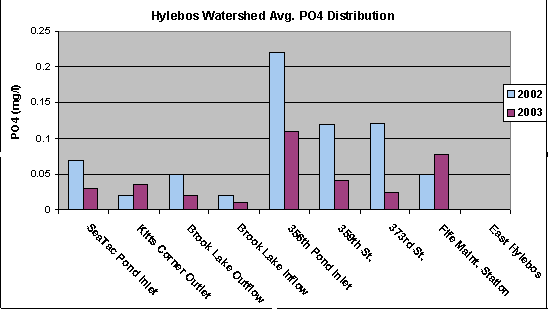
Phosphorus usually occurs in nature as phosphate, which is a phosphorus atom combined with four oxygen atoms (PO4) (Murdoch et al 2001). Testing the amount of phosphorus, in water bodies, is a useful indicator for determining potential problems with excessive plant and algae growth. High levels of phosphorus can result in eutrophication, which decreases the amount of dissolved oxygen, kills fish, and decreases the availability of other much needed nutrients in the water body.
The overall phosphate collections taken from each site proved to be relatively low and insignificant. However, even minute amounts of phosphate as low as 0.01 mg/L can have a dramatic impact on the succession of aquatic and plant life.
Phosphorous concentrations EPA (2002) limits of 10.0 mg/L (0.01 mg/L) for Ecoregion II. Phosphorous concentrations ranged from 0.0130 - 0.0773 mg/L, excluding Devil's Triangle and the East Hylebos (which had no reported phosphorous values). At the Devil's triangle, a significant hit of Phosphorous was recorded, with measured concentrations of 0.1620 mg/L. This high phosphorous concentration is most likely the result of land uses above the retention pond. However, it appears that the high concentrations of phosphorous recorded at Devil's Triangle are mediated elsewhere in the watershed, as all downstream sites have significantly lower (although not optimal) levels of phosphorous. See Table 2 for all phosphorous data recorded at each site.
Figure 5.
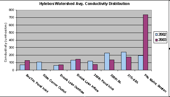
Conductivity and turbidity determines the amounts of dissolved and suspended solids located in a water system. Conductivity is an indirect measurement of the presence of inorganic solids such as chloride, nitrate, sulfate, phosphate, sodium, magnesium, calcium, iron, and aluminum (Murdoch et al 2001). Figure 5 shows the average conductivity distribution for 2002 and 2003. Conductivity measurements for Hylebos Creek seem to be remaining at a healthy level, with the exception of the Fife Maintenance Station. The level increase could be due to an increase in urbanization, agriculture, industrial development, or a faulty Vernier reading. Generally, a healthy stream system will range between 150-500 umhos/cm.
Conductivity was within acceptable ranges (< 500 mS/cm) at all sites, except for at the Fife Station (Murdoch et al. 2001). At the Fife station, conductivity was recorded at 739.87 mS/cm.
Figure 6.
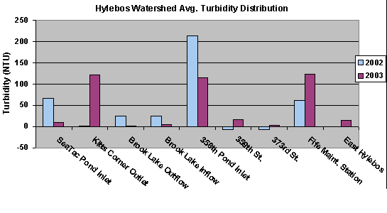
Turbidity is the measure of the cloudiness of water (Murdoch et al 2001). Low levels of turbidity can indicate a healthy, stable area and success of a stream. However, high levels of turbidity pose several problems for stream systems. Turbidity blocks out light needed by submerged aquatic vegetation (Murdoch et al 2001). According to the USGS, the turbidity of surface water is usually between 1 NTU and 50 NTU. Low levels of turbidity can represent a healthy functioning stream system, whereas higher levels of turbidity can cause serious problems and dramatically effect the water system.
Turbidity in the Hylebos watershed was highly variable, ranging from 2.0 to 123.67 N.T.U. Nearly all exceeded the EPA (2002) criteria, with the exception of 373rd St., Brook Lake Inflow, and Brook Lake Outflow. The most notable problems with turbidity was recorded at Devil's Triangle (115.0 N.T.U.), Fife Station (123.67 N.T.U.), and Kitts Corner Retention Pond Outflow (122.60 N.T.U.). All of these sites have a cloudiness from the high levels of suspended solids entrained in the water column. A significant source of sediments exists between the Fife Station site and the 373rd St. and East Hylebos, given that the recorded turbidities are significantly lower (2.7 and 13.3 N.T.U. respectively). It is likely that the heavy industrial/commercial land uses upstream of the Devil's Triangle retention pond are the result of the high turbidities recorded at this site. Also, a significant source of sediments must exist either within or before the Kitts Corner Retention Pond Outflow given the high values recorded here (122.6 N.T.U.). See Figure 6. for all turbidity data recorded at each site.
The macro-invertebrate data indicates that the watershed is impaired as a whole. While the macro-invertebrate surveys at 359th St. and the East Hylebos yield EPT/C ratios of 10.0 and 4.86 respectively, most sites were significantly lower in EPT taxa and were dominated by other taxa (e.g., Daphnia, Amphipods, and Oligochaetes). While the Brook Lake Inflow did have an EPT/C ratio of 10.0, the taxa was dominated by other taxa, with only 10 Ephemeroptera observed. The dominant taxa observed at most of the sites are indicative of poor water quality, and suggests that the Hylebos watershed's biotic community is impaired as a result of poor or degraded water quality. While the nutrient concentration and other physical data collected at the sites do not definitively indicate that the watershed is degraded significantly.
Figure 7.
.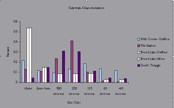
Sediment characterizations for each site are not reported here as a result of a failure to report results on time. However, analysis of the sites with reported data can be of some use. Looking at Figure 7, the sediments were failure evenly distributed at the Kitts Corner Retention Pond Outflow. In contrast, the other sites reported on here show clearly dominant sediment sizes, or size ranges. At the Brook lake sites, the sediments were dominated by >2mm sized gravel by percent dry weight. A clear decline in percent composition by dry weight of smaller sediment size classes can be seen by looking at Figure 7. The Fife Station and Devil's Triangle sediment samples indicate that the sediment is dominated by the 1 mm - 125 micron sized sediment. The dominance of smaller sediments at these sites may be a function of high sediment loading, given that both sites had high turbidities (123.67 and 115.0 N.T.U. respectively). However, Kitts Corner also had high turbidity values. The difference in sediment composition may be the result of sediment deposition induced by the passage of water through the settling pond and/or the wetland area. The presence of these features at the site may result in conditions sufficient enough to alter the substrate composition when compared to the Fife Station and Devil's Triangle sites.