

|
|
|
| Main | Introduction | Methods | Results and Discussion | Data Repository |
| Temperature | Salinity | Density | Dissolved Oxygen | Fluoresence | Transmissivity | Secchi-Turbidity | Phytoplankton | Sediments & TOC |
| CTD Results
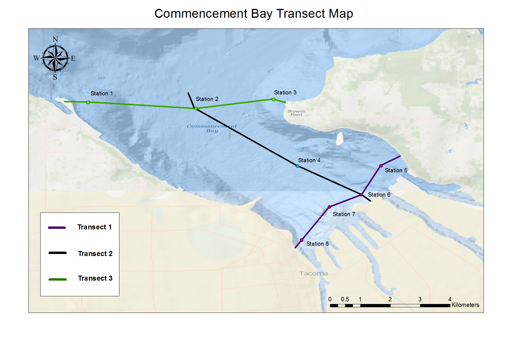
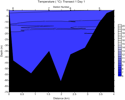
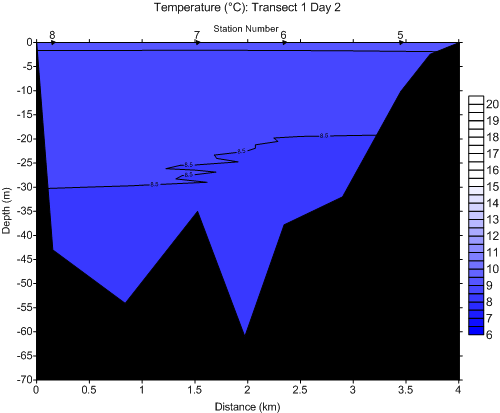
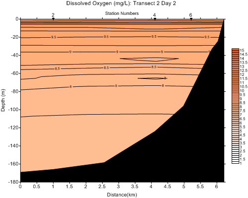
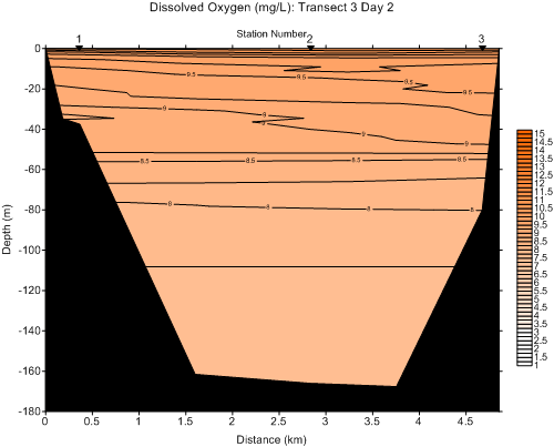
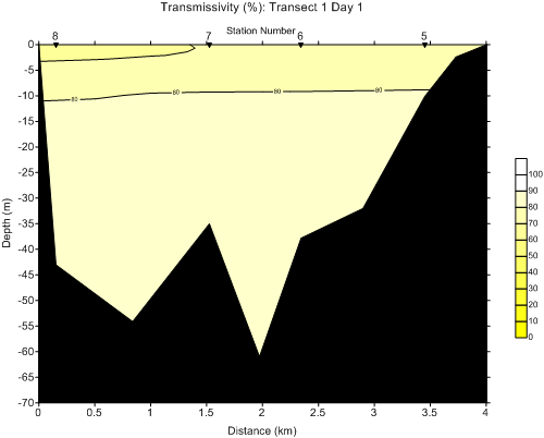
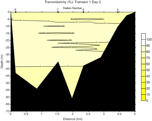
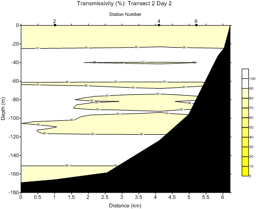
On April 11, 2014 (day 1), stations 4-8 were sampled. On April 18, 2014 (day 2), stations 1-8 were sampled. Three transects were developed for sampling sites. Transect 1 includes stations 8, 7, 6, and 5 (shown on the map below in purple). This transect extends from the Thea Foss Waterway to the Hylebos (left to right on profiles). Transect 2 includes stations 2, 4, and 6 (shown on the map below in black). This transect extends from mid-channel to the sewage outflow buoy (left to right on profiles). Transect 3 includes stations 1, 2, and 3 (shown on the map below in green). This transect extends from Point Defiance Yacht Club to Brown's Point ( left to right on profiles). Transect 1 is pictured twice for comparison of each day the transect was sampled. |
 |
 |
 |
 |
|
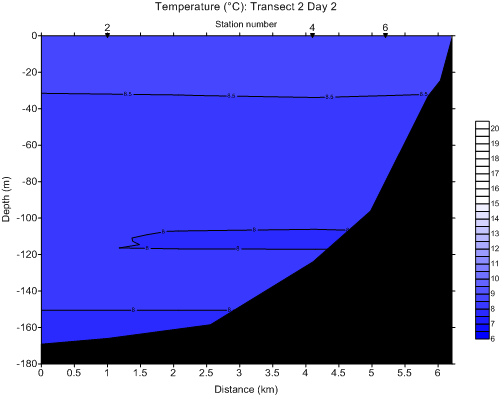
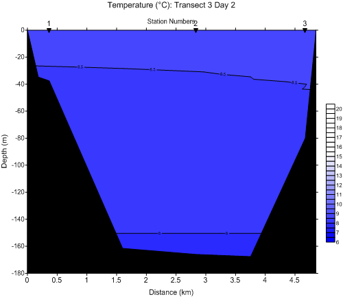
Temperature is reported in °C. All transects show decreasing temperature with depth. Deeper water has less access to warming sunlight and colder water is denser than warmer water, causing it to sink. However, some transects are more uniformly mixed than others. Transect 1 is the most well-mixed and is also the shallowest. Transects 2 and 3 are deeper transects and appear to be more stratified, with layers of different temperatures seen throughout the water column. Average temperature on both sampling days was approximately 8.5° C. Near the surface, temperature was close to 9°C and at the bottom it was close to 8°C. Transect 2 showed an area of decreased water temperature from stations at 100-120m below the surface. This decrease in temperature is likely attributed to the sloping bathimetry of Commencement Bay as you move from station 6 out to the middle bay. The overall range of observed Commencement Bay temperature was 8-10°C. |
 |
 |
 |
 |
|
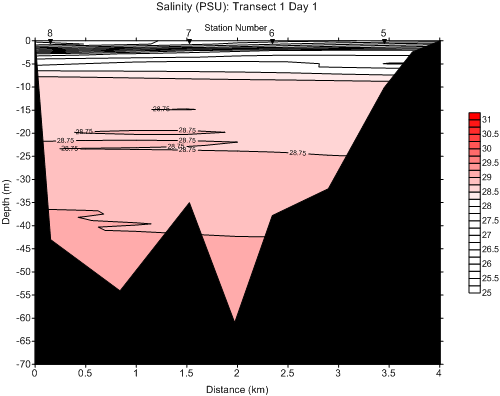
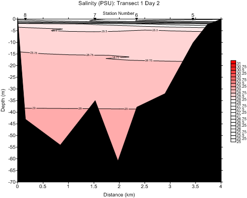
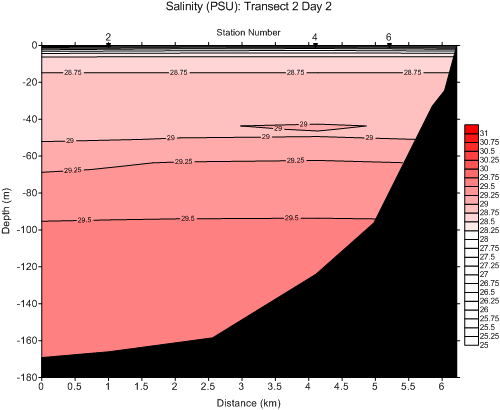
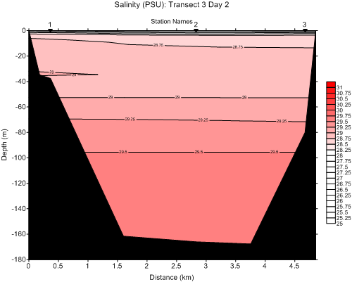
Salinity is reported in PSU. All stations show increased salinity with depth. Salinity is inveresly related to temperature. Transect 1 was freshest on top, likely due to its proximity to freshwater sources (i.e. the Puyallup River), starting as fresh as 25 PSU at the surface. Transect 1 was sampled following a peak inflow of Puyallup River inflow (approximately 5,900 cubic feet per second) on April 10, 2014. This inflow increased the freshness of the surface layer for transect 1, day 1 from 0-8m below the surface. Transect 1 is the most stratified, especially on day 1. Water began very fresh and increases rapidly in PSU from the surface, ranging from 25-28.75 PSU. Transect 1 day 2 appeared slightly less stratified, with a range from 25-29 PSU. Although the range was the same, the 8m deep fresh layer was not observed. However, there is a shallower fresh layer from 0-3m below the surface. April 18, 2014 was a peak flow day for the Puyallup River as well, but it is likely that the effects were not yet as detectable as they were on the 11th, the day after a peak flow. Transects 2 and 3 had the highest salinities and present observable layers of salinity from 28-29.5. There is a shallow fresh layer from 0-3m below the surface. The surface of each was less saline than transect 1, day 1 or day 2. The overall range of observed Commencement Bay salinity was 25-29.5 PSU. |
 |
 |
 |
 |
|
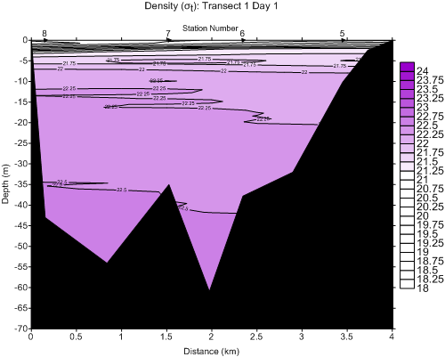
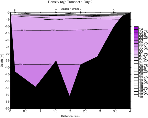
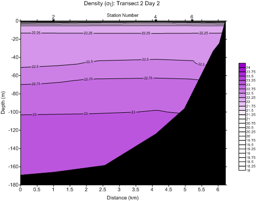
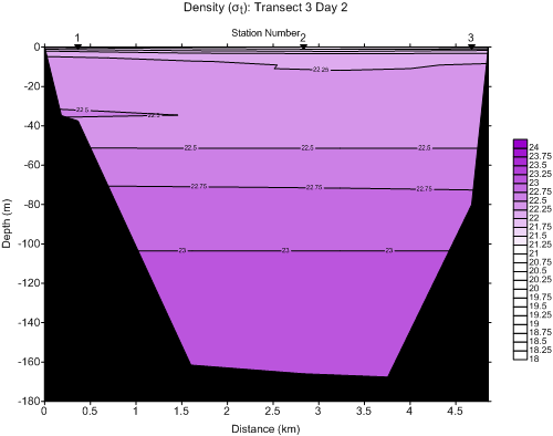
Density is reported in σt. All stations show increased density with depth. Density is directly related to salinity and inversely related to temperature. Density profiles were nearly identical to salinity profiles. Least dense water is found at the surface of the water column and most dense water is found at the bottom of the water column. Denser water is more likely to sink, which explains this relationship and also the connection to salinity, as salinity increases density. Transect 1 day 1 ranged from 21.75-22.5 σt and was likely influenced from the Puyallup River peak flow, as it represented least dense, fresher water at the surface (from 0-5m below surface). This is consistent with the Puyallup River station (7) being included in transect 1. Transect 1 day 2 was more dense at the surface than day 1. It is assumed that because April 18, 2014 was a peak flow day for the Puyallup River, effects were not yet as detectable as they were on the 11th, the day after a peak flow. Transect 2 ranged from 21.75-23 σt. Transect 3 ranged from 21.75-23 σt as well. Transects 2 and 3 represented nearly identical profiles, and were the deepest stations. The overall range of Commencement Bay density was 21.75-23σt |
 |
 |
 |
 |
|
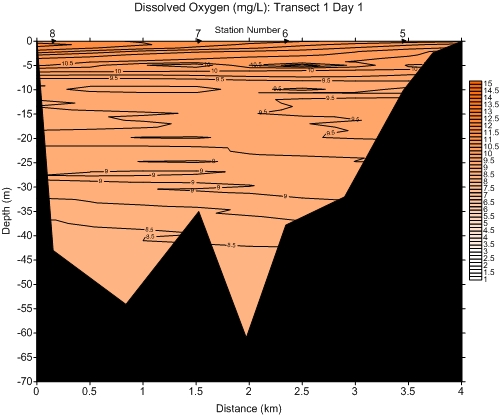
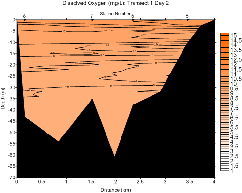
Dissolved oxygen levels for each transect are reported in mg/L. All stations show decreased dissolved oxygen with depth. Transect 1 showed the highest surface dissolved oxygen at 10.5 and 10 on days 1 and 2, respectively. Transect 1 showed a ranged of dissolved oxygen from 8.5-10.5 mg/L. The range was greater on day 1 (8.5-10.5mg/L) as compared to day 2 (9-10mg/L) for transect 1. Transects 2 and 3 ranged from 8-10mg/L. The overall range of Commencement Bay dissolved oxygen was 8-10mg/L. The Washington State Department of Ecology has developed dissolved oxygen criteria for marine waters, which are provided as reference below: 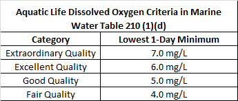 https://fortress.wa.gov/ecy/publications/publications/0610091.pdf According to these parameters, it would appear that our samples have extraordinary quality, as the lowest minimum we found was approximately 8mg/L. However, it is important to consider that our sampling was only done on two days and during the day each time. Oxygen enters the water through diffusion from the atmosphere and photosynthesis. Dissolved oxygen levels are highly influenced by salinity and temperature, and can vary seasonally (NOAA, c2014). Lowest levels correlate with high phytoplankton populations in the late summer months, when temperatures are also very high. Dissolved oxygen also tends to be lower at night, which would affect our assumed "lowest minimum." More data would be required to put our data into a greater context. |
 |
 |
|
Comparisons of CTD and discrete dissolved oxygen levels represents a linear trend that depicts an R2 value 0.8267. This value indicates that the regression line fits the data well, establishing a good correlation between the CTD data and the discrete data. This reinforces the validity of laboratory analysis. |
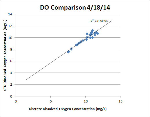
Comparisons of CTD and discrete dissolved oxygen levels represents a linear trend that depicts an R2 value 0.9098. This value indicates that the regression line fits the data very well, establishing a strong correlation between the CTD data and the discrete data. This reinforces the validity of laboratory analysis. |
 |
 |
 |
 |
|
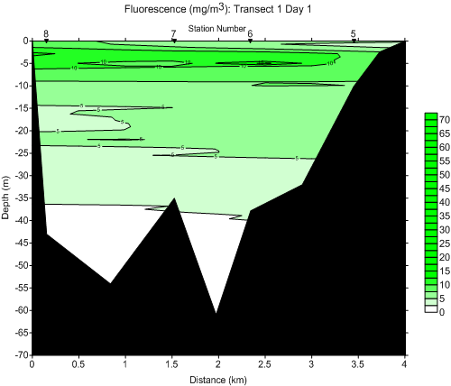
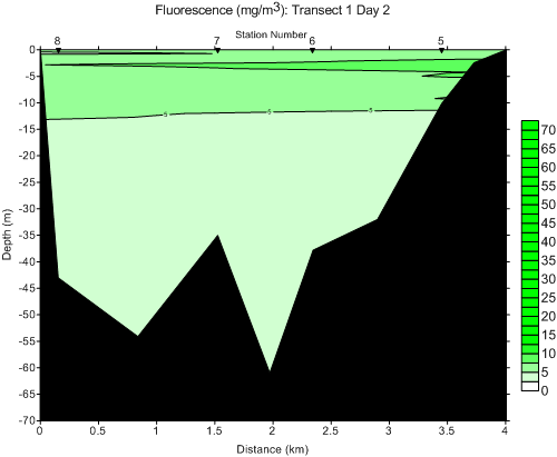
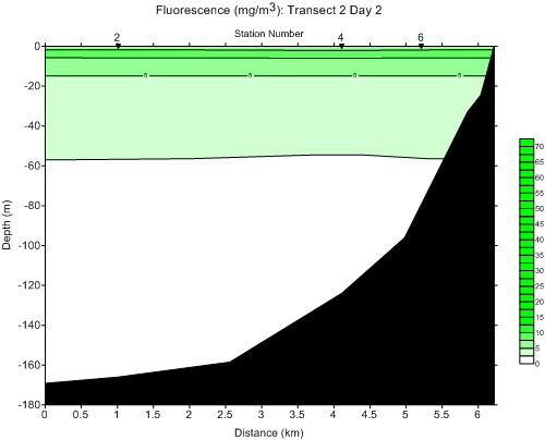
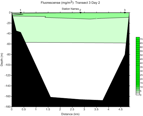
Fluorescence is reported in mg/m3 .Transect 1 showed the highest fluorescence levels, ranging from 5-10 mg/m3. On day 1, levels extended to approximately 40m below the surface. Transect 1 day 2 showed the same range as day 1, but levels were detected throughout the entirety of the water column. Higher levels were seen from station 7 to 5 than were found at station 8. Transect 2 ranged from 5-10mg/m3 and extended from 0-60m below the surface. Transect 3 was almost identical in values and depth, each representing a sharp end to fluorescence detection at approximately 60m below the surface. Highest fluorescence levels are seen near the surface for each transect, which is to be expected since phytoplankton are found closer to the surface of the water column. The overall range of Commencement Bay fluorescence was 0-10mg/m3. |
 |
|
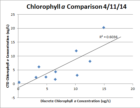
Fluorometer analysis was only conducted for April 11, 2014 due to a broken fluorometer during analysis on 4/18/2014. Consequently, there is only CTD and discrete chlorophyll data comparison for April 11, 2014. An R2 value of 0.6036 indicates a relatively poor correlation betwen CTD and discrete chlorophyll data, which is likely indicative of the failing fluorometer. Additionally, the 11th was the first day of field and lab analysis, increasing the likelihood of analyst error. |
 |
 |
 |
 |
|
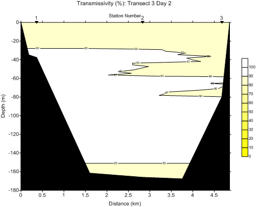
Transmissivity was recorded in percentage. CTD data indicates suspended particles within the water column. April 18, 2014 (Day 2 Transect 1), represents an increase in suspended particles in the under 6m of the water column when compared with April 11, 2014 (Day 1, Transect 1). This is likely due to the increased precipitation preceding sampling and increasing sediment load to Commencement Bay from the Puyallup River. Near the Hylebos Waterway (right side of transect 1 graph) there is also increased particle suspension throughout the entire water column, which is not seen in Transect 1, Day 1. On April 18, 2014 in Transect 2, increase in suspended particles is seen near the sewage outflow buoy, from 60-120m. This is likely an indication of settling particulates from the Puyallup River plume at the surface. On April 18, 2014 in Transect 3, increase in suspended particles is seen from approximately 0-30m below the surface from station 1 to 2. The presence of suspended particles at this depth could be from the Puyallup River sediment inflow or effluent discharge, due to the depth and proximity to the wastewater treatment plant. The depth of suspended particles increases near Brown's Point (station 3) to 0-80m. The increase in particle suspension could be an indication of the current speed as water moves around the curve at Brown's Point. The overall range of Commencement Bay transmissivity was 80-100%. |
 |
 |
|
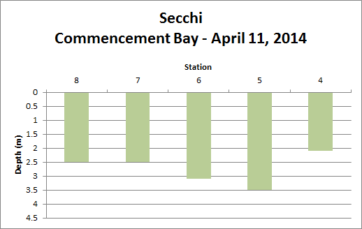
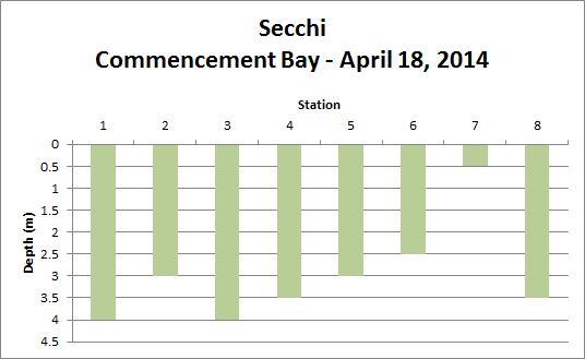
Secchi data indicates that visibility with Commencement Bay ranged from 0-4m. Greatest visibility was found at stations 2 and 3 on day 2 (April 18, 2014) at 4m. We would expect lowest visibility (and therefore shallow secchi depth) at stations 6 and 7 which are located near the Puyallup River outflow. The increase of sediment load in the water column due to the river results in low visibility, which is demonstrated by the secchi data from each day, with depths of approximately 3 and 2.5m on day 1 (April 11, 2014) and 2.5 and 0.5m on day 2 (April 18, 2014). Station 7 on day two (April 18, 2014) had the lowest visibility of all stations on either sampling day. Transect 1, station 7 had 2m less visibility on day two (April 18, 2014) then it had the previous week, due to the sediment load from peak Puyallup River flow compounded by heavy precipitation preceding the sampling day. The overall range of Commencement Bay secchi depth was 0.5-4m. |
 |
 |
|
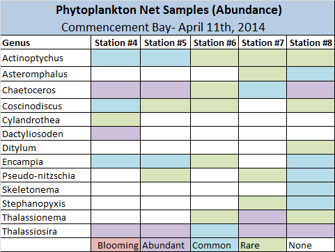
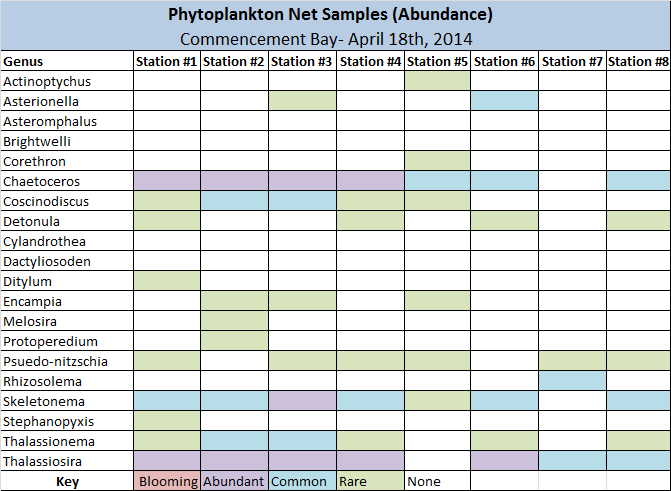
Phytoplankton net samples were qualitative rather than quantative and used only to estimate abundance of phytoplankton species by genus. Phytoplankton were collected using a 20 micron mesh net. Phytoplankton counts on April 11, 2014 revealed that abundant genera were chaetoceros spp., thalassiosira spp., and dactyliosoden spp. Common genera were chaetoceros spp., thalassiosira spp., pseudo-nitzschia spp., skeletonema spp., coscinodiscus spp., encampia spp., stephanopyxis spp., and actinoptychus spp. Phytoplankton counts on April 18, 2014 revealed that abundant genera were chaetoceros spp., skeletonema spp., and thalassiosira spp. Common genera were aserionella spp. , chaetoceros spp., coscinodiscus spp., rhizosolema spp., skeletonema spp., thalassionema spp., and thalassiosira spp. None of the sighted genera were found to be blooming. This is consistent with the low observed fluorescence levels. |
 |
 |
|
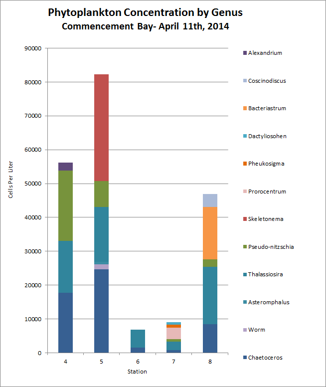
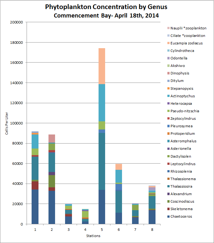
Phytoplankton surface samples were qualitative due to the fixed volume of the sampling jars in which they were collected. Consequently, they can be used to approximate phytoplankton populations in cells/L from the surface of the water column. On April 11, 2014, the highest abundances were found in chaetoceros spp., thalassiosira spp., skeletonema spp., and bacteriastrum spp. Stations 4 and 5 had high abundances of pseudo-nitzschia spp. On April 18, 2014, the highest abundances were found in thalassiosira spp., chaetoceros spp. , and actinoptychus spp. A high prevalance of eucampis zodiacus was found at station 5. Many more genera were observed on April 18, 2014 (day 2) than were found on April 11, 2014 (day 1). Additionally, zooplankton were only observed on April 18, 2014 (day 2). |
|
Five nutrients were tested for in Commencement Bay. These included Si(OH) 4, PO4, NO3, NO2, and NH4. Dissolved Organic Nitrogn (DIN) is most commonly found in marine waters in the forms of the afforementioned nitrogen compounds: NO3, NO2, and NH4. Each source is a primary source of nitrogen for phytoplankton. PO4 is a primary source of marine phosphorous for phytoplankton and is crucial to phytoplankton health and development. Si(OH)4 is an important compound in the development of diatoms. |
 |
 |
|
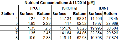
On April 11, 2014, Si(OH)4 analysis reveals a general trend of higher concentrations of Si(OH)4 at the surface as compared to the bottom. This result was peculiar as we would expect nutrients to be higher at the bottom, due to the rapid consumption of nutrients at the surface by phytoplankton. The high silicate concentration indicates the possibility of silicate inflow from Puyallup River sediments. These results will be checked further for any possible error. |
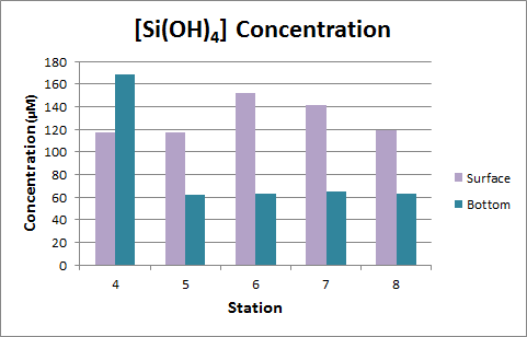
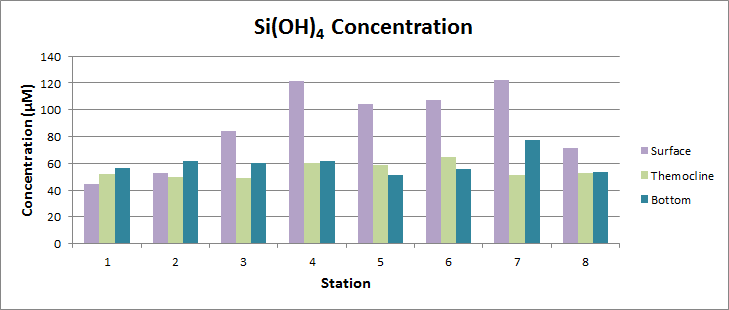
On April 18, 2014, Si(OH)4 analysis reveals a general trend of higher concentrations of Si(OH)4 at the surface as compared to the bottom and thermocline. This result was peculiar as we would expect nutrients to be higher at the bottom, due to the rapid consumption of nutrients at the surface by phytoplankton. The high silicate concentration indicates the possibility of silicate inflow from Puyallup River sediments. Thermocline and bottom water samples were very similar, and in some cases (stations 1,2, and 3) the surface, thermocline, and bottom water samples were very similar in concentration. These results will be checked further for any possible error. |
 |
 |
|
The table above compares PO4, Si(OH)4, and DIN concentrations for surface and bottom samples from April 11, 2014. PO4 and DIN concentrations were higher at the bottom, but Si(OH)4 concentrations were higher at the surface. |
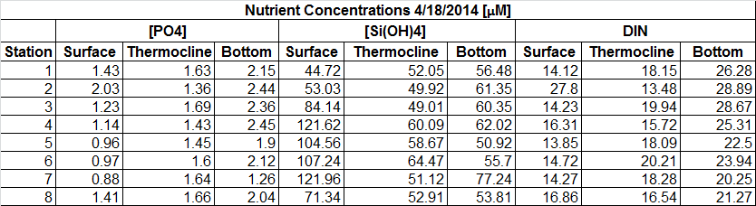
The table above compares PO4, Si(OH)4, and DIN concentrations for surface, thermocline, and bottom samples from April 1, 2014. PO4 and DIN concentrations were highest at the bottom, followed by thermocline and finally surface. Si(OH)4 concentrations were higher at the surface in most cases, and thermocline and bottom concentrations were relatively the same. |
 |
 |
|
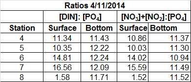
For April 11, 2014, ratio comparisons were calculated for [DIN]: [PO4] and [NO3]+[NO2]: [PO4]. Using the Redfield Ratio as reference, we would assume that open ocean ratios of nutrients would reflect a 106:15:1 ratio of C:N:P (Weber et. al, 2010). Consequently, we would expect that our estuarine system would reflect something close to a 15:1 ratio of N:P. We find that our values are lower than expected, indicating that N sources are being depleted relative to P in both ratio comparisons. |
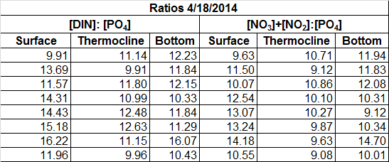
For April 18, 2014, ratio comparisons were calculated for [DIN]: [PO4] and [NO3]+[NO2]: [PO4]. Using the Redfield Ratio as reference, we would assume that open ocean ratios of nutrients would reflect a 106:15:1 ratio of C:N:P. Consequently, we would expect that our estuarine system would reflect something close to a 15:1 ratio of N:P. We find that our values are lower than expected, indicating that N sources are being depleted relative to P in both ratio comparisons. |
 |
|
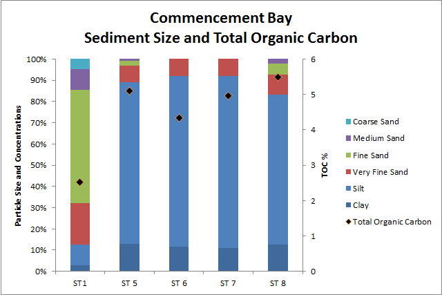
Sediment data represents particle size concentrations for all collected sediment samples from Commencement Bay on both days. Sediment samples were collected from stations 1, 5, 6, 7, and 8. Stations 5-8 were primarily silt, with some clay and very fine sand. All were similar in composition. Station 1 had a differing composition. Stations 5-8 would be classified as silt loam there soil texture. Station 1 would be clasified as just sand. Stations 5-8 have a higher percentage of finer sediments because all four of them are located near freshwater waterways. These waterways carry a lot of suspended particles but when they hit the bay they slow down, allowing these fine sediments to settle out. These stations also have a higher percentage of TOC because the waterways bring down a lot of organic matter as well as contaminants such as fertilizer, that raise the TOC content. The nearest shore to station 1 is mostly composed of cap material over the ASARCO slag. The erosion of this cap material leads to a higher percentage of fine sand in the sediment as well as a lower TOC content. |
|
References Arndt S, Lacroix G, Gypens N, Regnier P, and Lancelot C. 2011 Nutrient dynamics and phytoplankton development along an estuary-coastal zone continuum: A model study. Journal of Marine Systems 84 (49-66). NOAA. [Internet] c2014. Dissolved Oxygen. [cited 2014 May 3]. Available from http://oceanservice.noaa.gov/education/kits/estuaries/media/supp_estuar10d_disolvedox.html. Washington State Department of Ecology (WSDOE). [Internet] c2014. Water quality standards for the surface waters of the state of Washington, chapter 173-201A WAC. [cited 2014 May 3] Available from https://fortress.wa.gov/ecy/publications/SummaryPages/0610091.html Weber TS and Deutsch C. 2010. Ocean nutrient ratios governed by plankton biogeography. Nature 467 (551-554).
|
| Main | Introduction | Methods | Results and Discussion | Data Repository |
| Created by Madison Drescher and Lauren Reetz |