   |
| Main | Introduction | Methods | Results and Discussion | Data Repository |
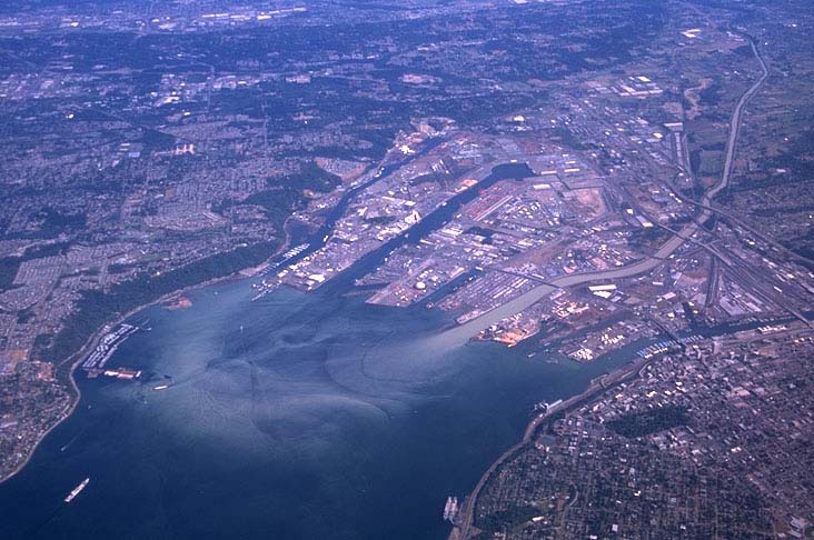 |
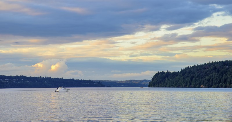
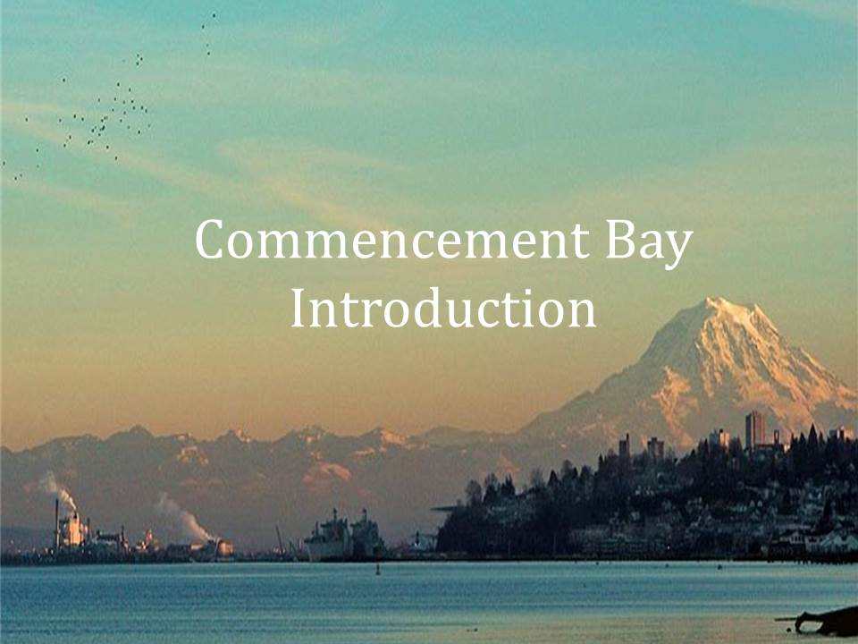
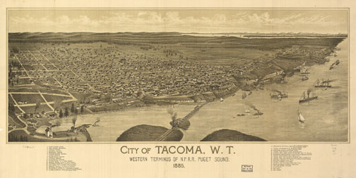
Once called “Shubahlup,” or “sheltered place” by the Nisqually and Puyallup peoples, Commencement Bay is part of the main basin of the Puget Sound estuary located within Washington State (WSDOE c2014). The city of Tacoma is located on the Bay, which is also home to one of the nation’s main seaports, the Port of Tacoma. More specifically, the Bay is located between Point Defiance and Brown’s Point at the southern end of the main basin, about 25 km south of Seattle (Cannon and Grigsby, 1982). Commencement Bay is part of the Puyallup River watershed and the mouth of the river is located within the Bay, visible in the picture to the left. Other freshwater sources to the Bay include many smaller creeks, such as Mason Creek, Puget Creek, and Hylebos Creek (Becker et. al, 2009). The Bay measures approximately 7.5 km along the southwest shore to Point Defiance, by 4.3 km across the inner bay, by 4.7 km along its northerly shore (Cannon and Grigsby, 1982). |
|
The history of the Commencement Bay area is very rich and highly influenced by anthropogenic contributions. Prior to European settlement, the historic reservation of the Puyallup tribe included 18,000 acres on the shores of the Bay, which was a valuable resource for harvesting salmon and shellfish (WSDOE c2014). The development of the Puget Sound was affected by many main events following European settlement. After Fort Nisqually was settled in 1833 by Hudson’s Bay Company of London, expansion quickly followed (Metroparks c2014). In 1853, the first sawmills were established along the Puget Sound. In the 1880s, the Northern Pacific Railroad reached Tacoma, coal mines began in Bellingham, and the ASARCO smelter plant site was created. In the 1920s, pulp mills began operations, and in 1965 the West Point Sewage Treatment Plant became operational. It was not until 1971 and 1972 that the Washington State Environmental Policy Act and the National Clean Water Act were enacted, and not until 1985 that the ASARCO smelter was closed (Dexter et al., 1985). As a result, pollution has become a pressing issue within Puget Sound and Commencement Bay especially. |
 |
|
Since the 1980s, the Environmental Protection Agency (EPA) and Department of Ecology (DOE) have discovered widespread contamination of the water, sediments, and upland areas of Commencement Bay, leading to its characterization as a “Superfund Site” in 1983 (WSDOE c2014). Pollution within the Bay includes conventional pollutants such as organic matter, plant nutrients, and pathogenic microorganisms. These types of pollutants can result in low dissolved oxygen within the Bay and high abundances of disease causing organisms. Toxic chemical discharge is another type of pollution present, likely due to industrial discharge to the Bay. Contaminants within the Bay include polynuclear aromatic hydrocarbons (PAHs) and polychlorinated biphenyls (PCBs); metals including copper (Cu), lead (Pb), arsenic (As), and iron (Fe); and finally phalates and dioxins (Partridge et al., 2010; Shults et al. 1987). |
The active harbor area and waterways of Commencement Bay serve as important migratory pathways and rearing areas for multiple marine species including migratory birds and fish. In fact, South Puget Sound and Commencement Bay provide for approximately 30% of the total midwinter waterfowl use of Washington’s coastal areas (USFWS, 2006). Commencement Bay boasts resources commercially, culturally, and recreationally, while also being esteemed for its beauty. Continued collaboration of agencies, organizations, tribes and other groups will ensure that restoration efforts for the Bay continue in the future to protect these precious resources. |
|
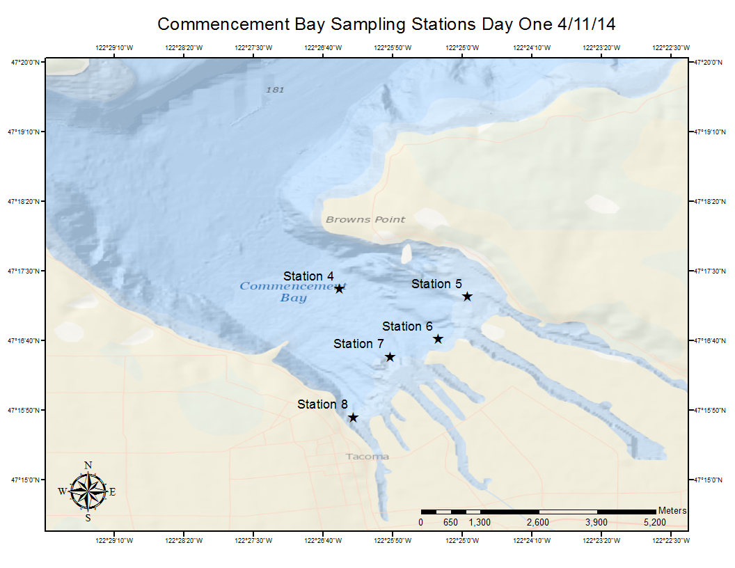
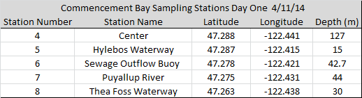
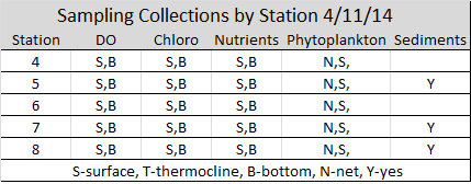
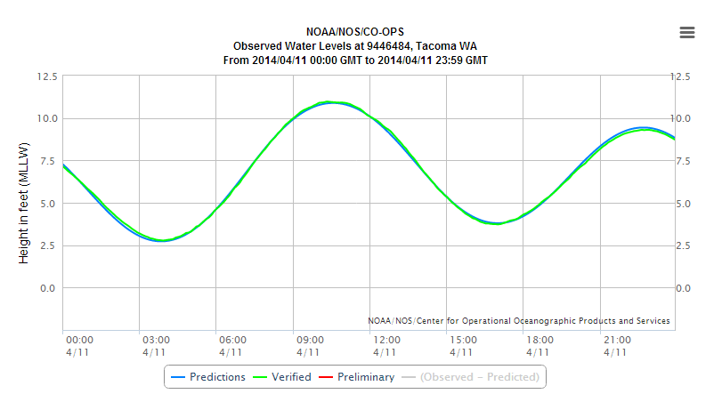
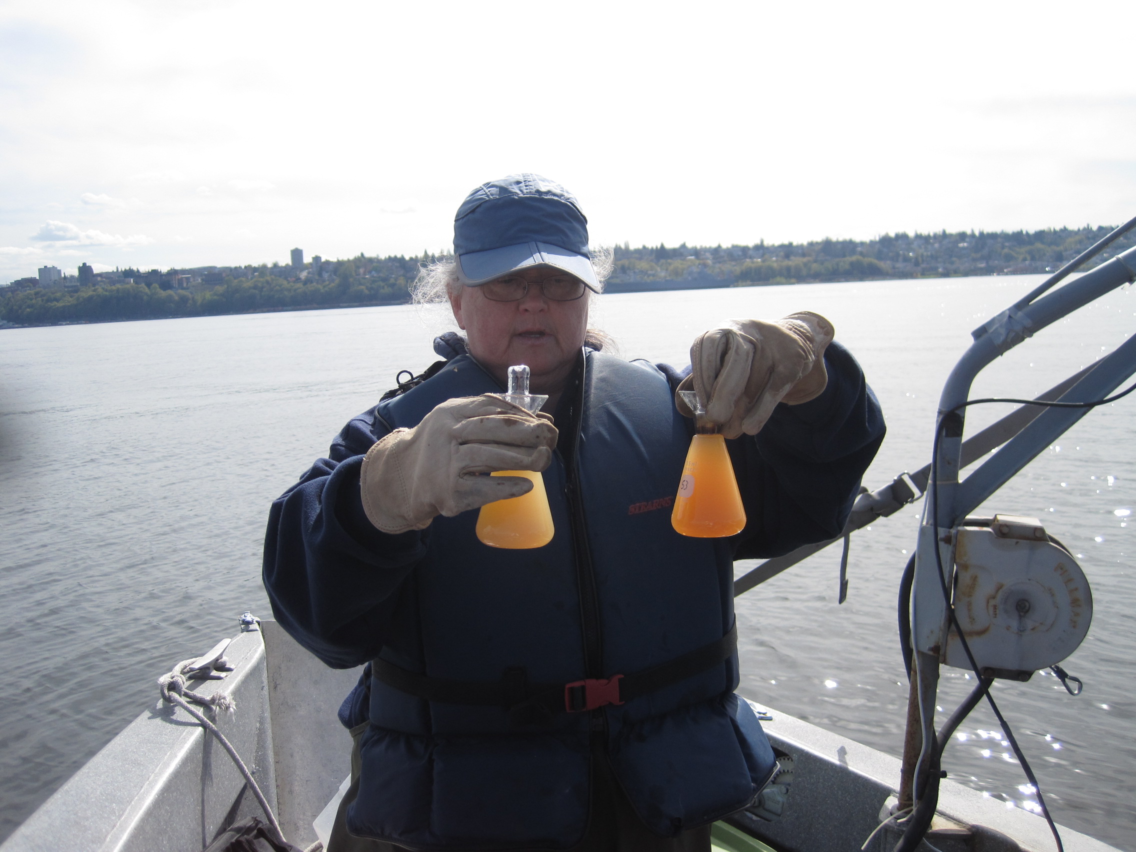
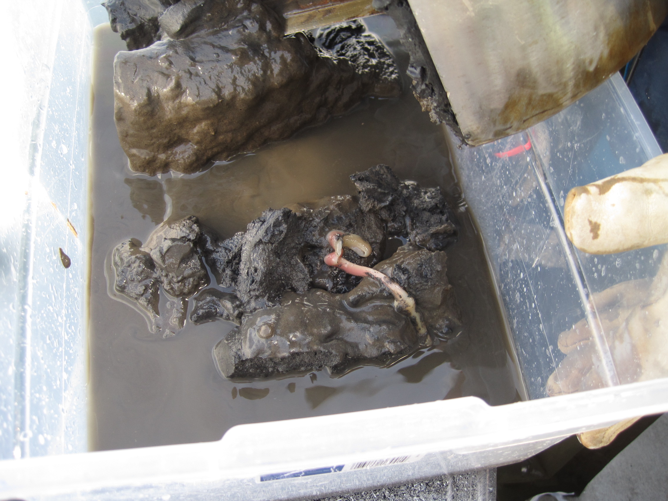
On April 11, 2014 (day 1), the University of Washington, Tacoma sampled Commencement Bay. Sampling took place aboard the City of Tacoma vessel “Baywatcher” and began with Team A, comprised of Cheryl Greengrove, Lauren Reetz, Madison Drescher, Richard Davis, Brandon Spencer and Shirley Low, with Captain Chris Burke and Mate Bill Essmeier. Team B followed with members Cheryl Greengrove, Alison Dunn, Corey King, Michelle Brant, Rafi Azami, and Taylor Wesenberg, with Captain Chris Burke and Mate Bill Essmeier. Sampling began at 9:30AM at high flood tide. Conditions were sunny, flat seas and no wind. Collectively on the 11th, teams A and B took samples at 5 locations within Commencement Bay. Team A sampled stations 7 and 8, while Team B sampled stations 4, 5, and 6. During each sail, surface and deep-water samples were collected at each location for dissolved oxygen, nutrients, phytoplankton (net and surface), and chlorophyll. Please see table below for detailed sampling collections. Secchi data was collected for each location and sediment samples were collected at stations 5, 7, and 8 using a Van Veen. During the first sail with Team A, a microplastics tow was initiated. Samping ended at 12:05PM during ebb tide.
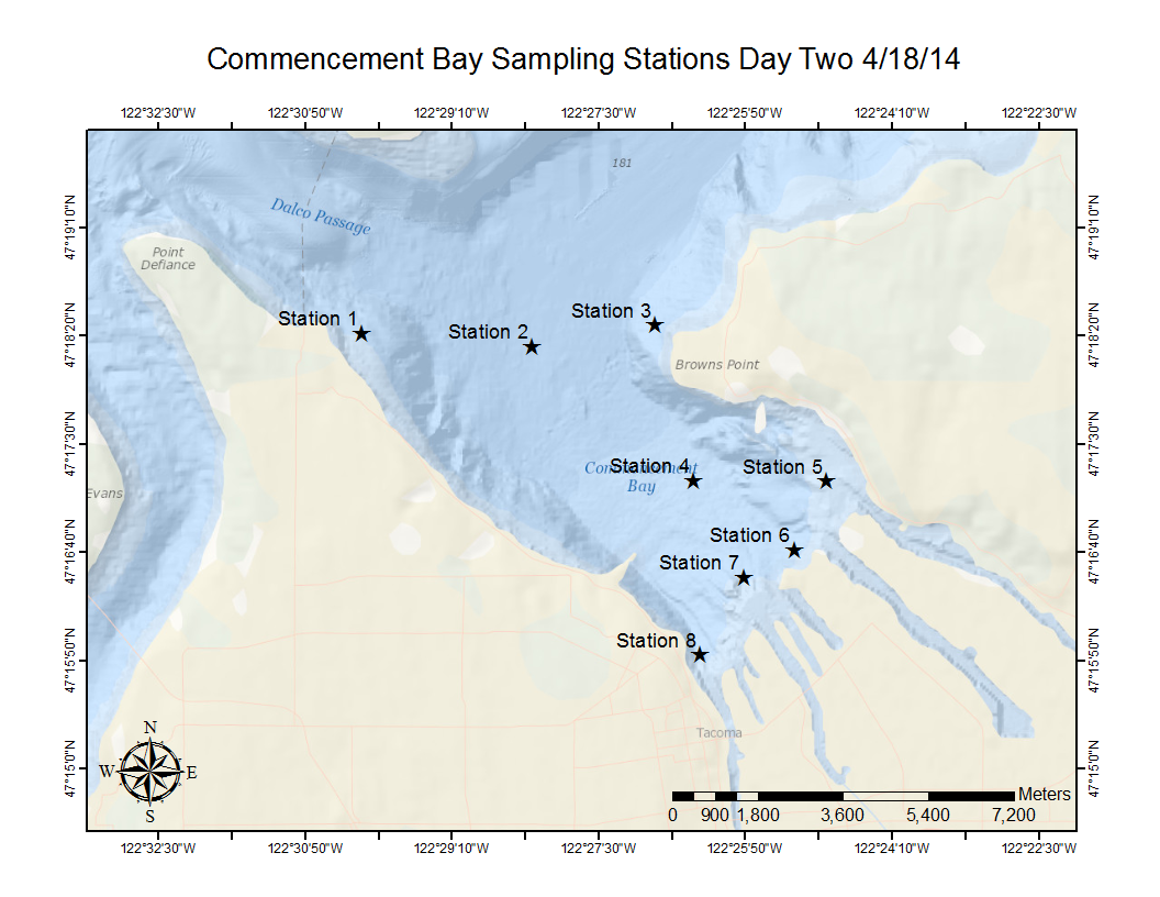
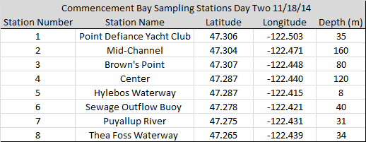
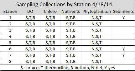
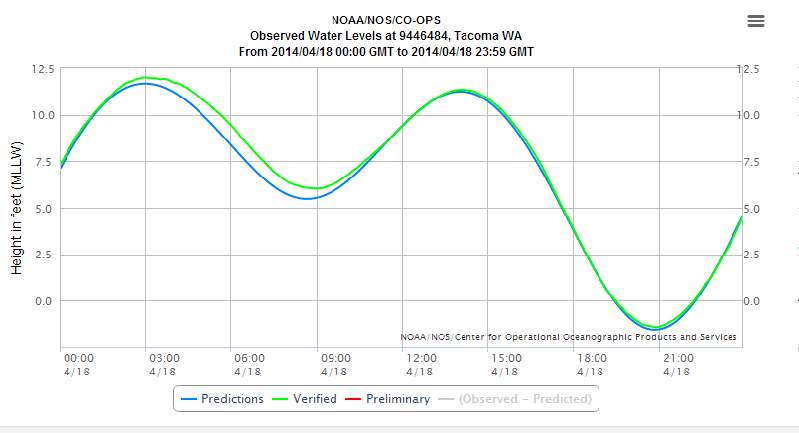
On April 18th, 2014 (day 2), the University of Washington, Tacoma sampled Commencement Bay once more. Sampling again took place aboard the City of Tacoma vessel "Baywatcher," but sampling team order was reversed. Team B began the sampling,with members Cheryl Greengrove, Alison Dunn, Corey King, Michelle Brant, Rafi Azami, and Taylor Wesenberg, with Captain Chris Burke and Mate Bill Essmeier. Team A followed with members Cheryl Greengrove, Lauren Reetz, Madison Drescher, Richard Davis, Brandon Spencer and Shirley Low, with Captain Chris Burke and Mate Bill Essmeier. Sampling began around 9AM, at low tide. Conditions were breezy and overcast, with some sun breaks. Collectively on the 18th, teams A and B took samples at 8 locations within Commencement Bay. Team B sampled stations 1-4, while Team A sampled stations 5-8. During each sail, surface, thermocline, and deep-water samples were collected at each location for dissolved oxygen, nutrients, phytoplankton (net and surface), and chlorophyll. Thermocline was determined to be at 3m. Please see table below for detailed sampling collections. Secchi data was collected for each location and sediment samples were collected at stations 1,7, and 6 using a Van Veen. During the second sail with team B, a microplastics tow was initiated. Sampling ended at 4:00PM during ebb tide. |
 |
 |
 |
 |
|
As compared to day 1 sampling (April 11, 2014), outflow from the Puyallup River was much higher on day 2 sampling (April 18, 2014). April 11, 2014 reflected discharge of approximately 4500 cubic feer per second, as compared to 6900 cubic feet per second on April 18, 2014. Sampling on April 11, 2014 was the day after a peak flow from the Puyallup River, while sampling on April 18, 2014 was the day of the peak flow from the Puyallup River. The variance in river outflow should effect freshwater volume within the Bay, suspended particle load, density, salinity, and likely most of the parameters we are measuring. |
 |
 |
 |
 |
|
References Cannon
GA and Grigsby MW. 1982. Observations of
currents and water properties in Commencement Bay. Boulder (CO): NOAA.
Report
No.: Technical Memorandum OMPA-22. Dexter
RN, Goldstein LS, Chapman PM, and
Quinlan EA. 1985.
Temporal trends in
selected environmental parameters monitored in Puget Sound. Rockville
(MD):
NOAA. Report No.: Technical Memorandum NOS OMA 19. Metroparks
Tacoma [Internet]. c2014. Tacoma, WA;
cited 2014 May 30. Available from http://www.metroparkstacoma.org/history-fort-nisqually/. Partridge
V,
Weakland S, Long E, Welch K, Dutch M. 2010. Urban Waters Initiative,
2008:
sediment quality in Commencement Bay [Internet]. Olympia (WA):
Washington
Department of Ecology Publication No. 10-03-019; [cited 2012 Jan 19];
171 p.
Available from: www.ecy.wa.gov/biblio/1003019.html Schults
DW, Ferraro SP, Ditsworth GR
and Sercu KA. 1987. Selected chemical contaminants in surface sediments
of
Commencement Bay and the Tacoma Waterways, Washington, USA. Marine
Environmental Research. 22(4):271-295. United
States Fish & Wildlife Service
(USFWS). 2006. Restoring our resources: the natural resource damage
assessment
and restoration program, Commencement Bay, Puget Sound, Washington [Internet]. [cited 2014
May 30]. Available
from http://www.fws.gov/contaminants/Documents/CBAYpdf3.pdf. University
of Washington, Tacoma. 2009. Commencement
Bay (Tacoma, WA) nearshore salmon habitat assessment [Internet]. [cited
2014
May 30]. Available from http://courses.washington.edu/commbay/salmon/UWT_comm_bay_salmon_hab_assess_final.pdf. Washington State Department of Ecology (WSDOE) [Internet]. c2014. Tacoma (WA): Urban Waters Initiative: Commencement Bay. [cited 2014 May 3]. Available from http://www.ecy.wa.gov.urbanwaters/commencement bay.html. Images (in order of appearance):
|
| Main | Introduction | Methods | Results and Discussion | Data Repository |
| Created by Madison Drescher and Lauren Reetz |