Final Gallery

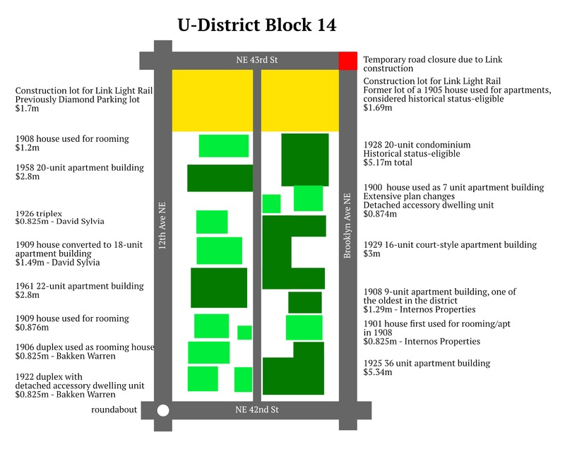
Present map of the block. Map created with Affinity Designer featuring the PT Serif font based on land survey conducted by Tyler Simpson and reference to Google Maps. University District (Seattle). Simpson, Tyler. Exported on January 22 2017.

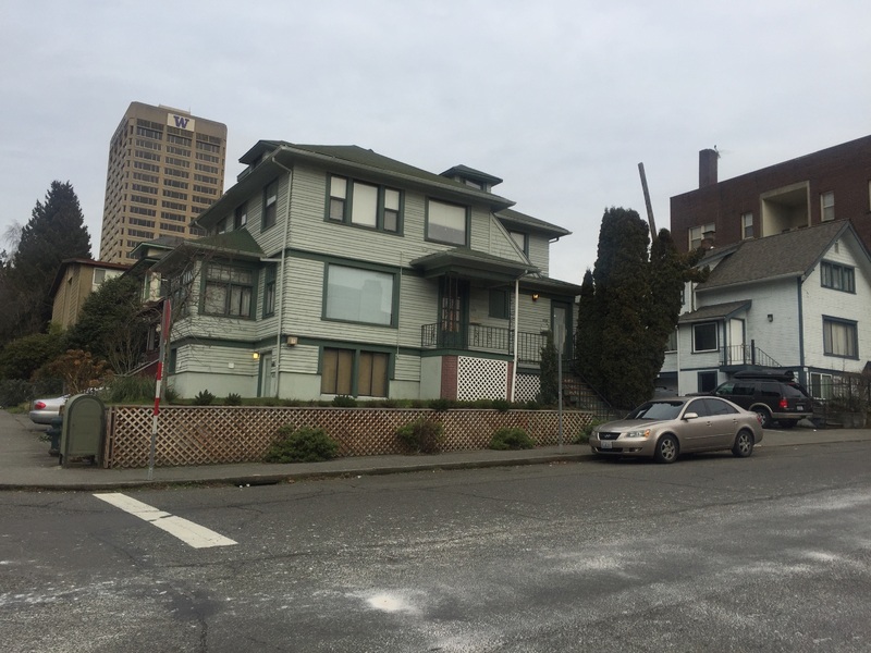
Typical student-used rooming house on the block.

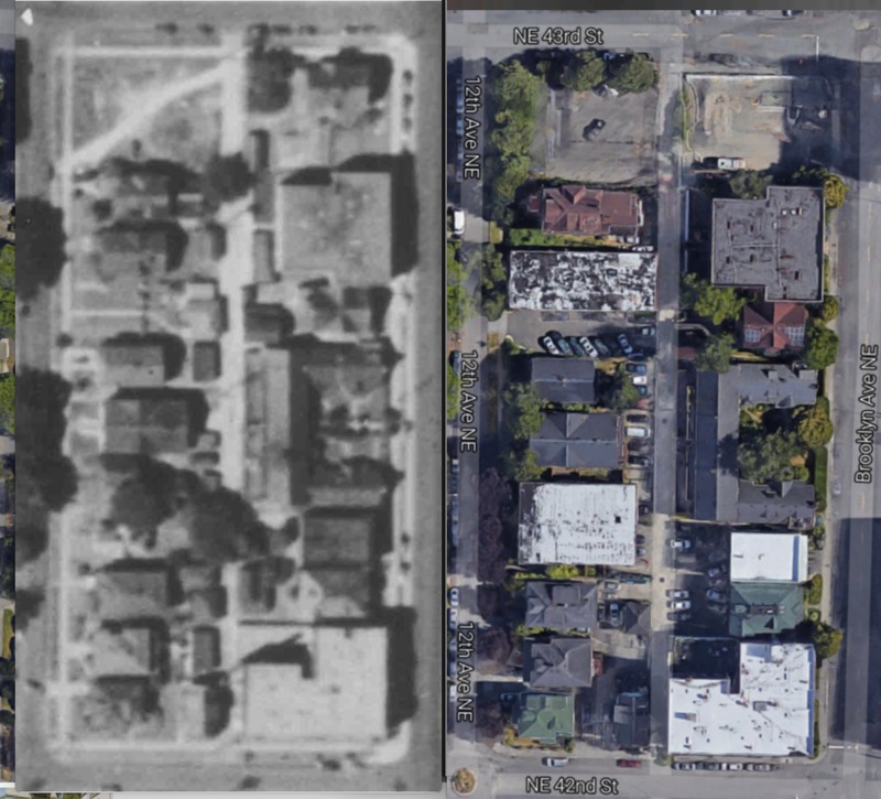
Very few buildings have changed in 80 years. Left: Excerpt from 1937 King County Aerial Survey. Right: Google Maps, 2017.
The block between 42nd and 43rd St and 12th and Brooklyn Ave NE has had a notable but relatively stable history to now, something that will soon change as the U District subway station and rezone develops. Prior to European American development, the block contained forest, berries, and deer and elk that were hunted with snares and spears by the Coast Salish people (Nielsen, p.1). The plot was homesteaded by a settler named Christian Brownfield in 1873, and slowly developed with strawberry farms and sparse housing. In 1885, it became part of James Moore’s Brooklyn Addition, with a platted grid, dirt roads, and wooden sidewalks (Nielsen, p.30). The earliest standing house, 4229 Brooklyn Ave, was built in 1900, the decade that the block developed as single family housing. Although it looks like the rest of the city, almost immediately these houses became University focused: in 1903, six UW professors lived together in that house, and sorority documentation shows students also resided in the block at the time (Tyee 1903 Yearbook). Leading up to the Alaska Yukon Exposition, the streets were paved with wood planks, many of which were not modernized until the 1940s (Nielsen, p.89).
Today, all single family-style housing on the block has been converted in city distinction as rooming houses and apartments for students. In the mid to late 1920s, three 16-36 unit apartment buildings opened (Seattle Historical Sites App). The only major difference from an aerial view since then has been the replacement of two houses with two modernist apartment buildings in 1958 and 1961 of lower contemporary attractiveness that were advertised for their included carpets, colorful appliances, drapes, and electric heating, hallmarks of that domestic era (Classifieds Section, 1961). Street trees on the block are now mature and large compared to a 1937 aerial survey, a result of the continual and gradual growth of the nature we’ve let exist (King County Aerial Survey, 1937). Interestingly, the lot on the north west corner has never been developed, currently serving Link light rail construction vehicles. Contrasting the minimal physical change over time, the demographics have rapidly shifted. In 1960, the census tract was over 94% white. That’s evolved to 78% in 1990, 67% in 2010, and now just 53% in 2015 (U.S. Census Bureau, 1960-2010).
With no individual home owners and having just been rezoned to allow mixed use developments up to 240’ tall (with nine percent of new units rent controlled as affordable), the block will likely face incredible change in the future (U District Rezone Map, 2017). The block will be a hub of transit-oriented development for the subway station opening next to it in 2021, with housing, stores, and bus stops for its users. Seattle’s plans to accommodate this transformation include many pedestrian improvements. These include landscaped bulb-outs, additional trees, climbing-side bike lanes, lanterns, and raised crosswalks, which will all improve safety by calming traffic, improving the experience for students and residents (U District Green Streets Concept Plan, p.3). The block currently feels like an early 20th century suburb, but in the next 20 years will become incredibly urban, finally matching the growing city Seattle has become in the past 20 years as the tech workers re-urbanize, albeit generally separate and within spaces like the U District may become (O’Mara, 2016). Though there are many people skeptical of whether anything but further gentrification will occur, hopefully the developments will allow it to continue to affordably serve the housing needs of UW students. For better or worse, it's a block on the cusp of change.
Works Cited:
Classifieds Section. The Seattle Times. 28 Nov. 1961. <http://infoweb.newsbank.com.offcampus.lib.washington.edu/iw-search/we/HistArchive/?p_product=EANX&p_theme=ahnp&p_nbid=H61N52IPMTQ4NzM2ODExNy43MTg2Mzc6MToxMzoxMjguOTUuMTA0LjY2&p_action=doc&s_lastnonissuequeryname=11&d_viewref=search&p_queryname=11&p_docnum=101&p_docref=v2:127D718D1E33F961@EANX-12C8A08A22A6DEC3@2437632-12BE140C8FC717E3@35-12C8AEF249A15500@>
King County Aerial Survey. Web. 1937. <http://cdm16118.contentdm.oclc.org/cdm/mapresources/collection/p16118coll2>
King County Parcel Viewer 2.0. Martin Luther King Jr County GIS Center, 2013. Web. 5 Dec. 2013. <http://gismaps.kingcounty.gov/parcelviewer2/>
Nielsen, Roy G. UniverCity: The City within City, the Story of the University District. Seattle: U Lions Foundation, 1986. Print.
O’Mara, M. “The Other Tech Bubble”. American Prospect Magazine, 2016. Web. 19 Feb. 2016. <http://prospect.org/article/other-tech-bubble-0>
Seattle Historical Sites App v2.0.1. Seattle Department of Neighborhoods, 2015. Web. <http://web6.seattle.gov/DPD/HistoricalSite/>
Tyee 1903 Yearbook. University of Washington Junior Class, 1903. Web. 16 Mar. 2017. <http://digitalcollections.lib.washington.edu/cdm/compoundobject/collection/uwdocs/id/5>
U District Rezone Map. City of Seattle Council Central Staff-GIS, 2017. Web. 20 Feb. 2017. <http://www.seattle.gov/dpd/cs/groups/pan/@pan/documents/web_informational/p2633813.pdf>
U District Green Streets Concept Plan. City of Seattle Department of Planning and Development, Spring 2015. Web. 16 Mar. 2017. <http://www.seattle.gov/dpd/cs/groups/pan/@pan/documents/web_informational/p2307055.pdf>.
U.S. Census Bureau. “Population Density, 1960.” Social Explorer. Web.
U.S. Census Bureau. Race: White Alone, 1960-2010. Prepared by Social Explorer. Web. 16 Mar. 2017. <http://www.socialexplorer.com/6f4cdab7a0/explore>
