|
The course objective was to use geovisualizations and landscape modeling techniques to effectively demonstrate landscape change. |
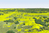
1972
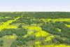
2000
Click on the image to download the full size geovisualization, other movies are available on the JRBP geovisualization project
|
Visualizing 30 years of Spatial and Temporal Landcover Changes in the James River Basin: Research Project by Teri Hunsinger Springfield, Missouri and its surrounding communities have experienced population increases that have the capability to greatly impact the landscape's systems and processes. The change that is brought about can take different shapes and forms. Gradual change, like the growth of a forest or the shifting of a stream channel, often goes unnoticed. Other environmental changes are not as easy to detect, such as diminishing water quality or loss of soil fertility. In addition changes can be products of the shift of land use practices to accommodate an expanding population, such as the construction of housing developments, shopping centers, and other infrastructure. Geospatial technologies have become the leading tools for monitoring landscape change. These technologies include simple tools such as paper maps as well as more sophisticated tools such as geographic information systems (GIS). GIS analysis and techniques allow us to produce two dimensional digital maps which show temporal changes at multiple scales. The integration of GIS and geographic visualizations (geovisualizations) can provide, leaders, decision makers and the public with support tools that convey the message of spatial and temporal change in an easily understandable manner. Through the geovisualization of the three dimensional environment, any person, not just those qualified in the geosciences, are able to witness a simulation of the dynamics of a landscape over time, draw conclusions based upon the relationships displayed, and make a decision based upon those conclusions. We use 30 years of satellite imagery to produce geovisualizations of the spatial and temporal landuse/land cover changes influenced by a dramatic population increase in the Springfield, MO region.
|
Dr. Moskal's Office: Bloedel Hall 334 |
Phone: 206.221.6391 |
Seattle WA, 98195-2100 |
Email: lmmoskal at u.washington.edu |
© 2003 - 2011 L.M.
Moskal - Last updated on
07.01.11 20:03
|