|
The course objective was to use geovisualizations and landscape modeling techniques to effectively demonstrate landscape change. |
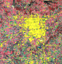
Satellite imagery (from the Landsat platforms) demonstrating the growth of the city of Springfield, MO from 1972 - 2000. The yellow areas in the graphic represent the urban area. |
Geospatial science, digital technologies and techniques allow for a synthetic approach to translate the real landscape and spatial experience to virtual landscape and spatial experience. Such techniques are just beginning to be utilized by resource manager, urban planners, scientist and educators to convey spatial and temporal concepts to public and other audiences. The goal of this graduate/senior level class was to utilize geospatial methods such as remote sensing, geographic information systems (GIS) and geovisualizations to demonstrate the landscape change affecting the city of Springfield, Missouri and surrounding areas since the 1970's to 2000. Three major component of the landscape were extracted from satellite imagery, these were:
Students in the class already had strong geospatial skills such as knowledge of advance GIS, remote sensing and spatial statistics. The student gain action oriented skills such as modeling, geovisualization, and landscape metrics. The geovisualizations and Power Point presentations (for the 2005 Missouri Natural Resources Conference) based on the student projects are features on this site. Examples of student made geovisualizations |
Dr. Moskal's Office: Bloedel Hall 334 |
Phone: 206.221.6391 |
Seattle WA, 98195-2100 |
Email: lmmoskal at u.washington.edu |
© 2003 - 2011 L.M.
Moskal - Last updated on
07.01.11 20:08
|