|
The course objective was to use geovisualizations and landscape modeling techniques to effectively demonstrate landscape change. |
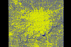
Click on the image to download the full size geovisualization, other movies are available on the JRBP geovisualization project
|
Effect on Water Quality of Urbanization within the James River Basin: Research Project by Chris Wood The urban areas of southwest Missouri are amongst the fastest growing metropolitan regions in the state and country. The growth in these areas has been sustained for a substantial period of time, leaving the landscape markedly different from even thirty years ago. This growth is occurring within an ecologically sensitive environment: the James River, which is inside the area of growth, is a national impaired waterway. Undoubtedly, this massive growth has affected, directly or otherwise, the surrounding environment. These environmental changes include diminished forest growth, or degradation of the water quality or soil fertility. Unchecked continued urbanization within this area has the potential to cause damaging and irreversible change to an already badly impaired water and eco-system. Through the use of geographic information systems (GIS), standard geospatial technologies for displaying temporal change are taken to the next realm. The combination of GIS and geographic visualizations generate a powerful tool to convey the spatial and temporal change in the subject area. When constructed carefully, such visualizations can be used as a public education tool, providing the lay person with the ability to clearly identify the spatial and temporal change in a selected subject area. The visualizations produced of Springfield (Missouri)'s southwest corner show the urban change over time, and the effect of this change on the water quality in the James River Basin (JRB). This area was chosen due to its rapidly increasing urban nature; close proximity to the JRB waterway; and closeness to forest and vegetation. |
Dr. Moskal's Office: Bloedel Hall 334 |
Phone: 206.221.6391 |
Seattle WA, 98195-2100 |
Email: lmmoskal at u.washington.edu |
© 2003 - 2011 L.M.
Moskal - Last updated on
07.01.11 20:03
|