Site report 2
The block is situated on a gentle slope. On a topographical map, 150 ft. in elevation runs near the southern end of the block, with 160 ft. cutting through the middle and reaching 170 ft. on the northwest corner. Overall there is about a 25-foot gain running northbound up the block, creating a 3.35% grade slope on Roosevelt way and a 4.5% grade slope on 11th avenue (Kroll, 1920). The land was forested before development, but no original trees remain.
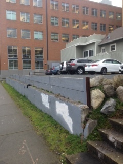
The gentle slope and relative lack of obstacles on the block made it a prime target for development. It was parceled off into lots as early as 1905, with the construction of single-family homes filling almost every lot in the next couple decades. These homes did require a fair amount of landscaping, as evidenced by the last remaining single family home located in the southeast corner of the block that is raised about five feet off street level, with containing walls lining the front façade. However, the scale of projects like the Roosevelt common apartment complex on the block show that the natural obstacles did not inhibit major development.
The block is almost completely paved over, especially on the northern side which contains a gas station and parking lot. Heavy traffic on 45th and the somewhat industrial nature of the gas station have probably leached chemicals into the groundwater around this area of the block. Runoff continues to travel south down the block, much like it must have when the land was undeveloped.
The greenery that remains is in the form of street trees, most of which seem to be fairly young, perhaps planted around the time Roosevelt commons was constructed in 2002 (Roosevelt, 2017). There is a more well established tree on the northern side of the block, but looking at King County parcel viewer, I realized that it was not present in the 1930’s meaning it must have been a somewhat recent addition. There is a well maintained and manicured garden surrounding the Taiwanese center building in the southwest corner, though this appears to be made up of mostly non-native plant species.
The vacant lot on the Southeast corner is the only part of the block that seems to have natural plant growth. There is moss growing out of the cracked concrete walls and grass coming out from under the gravel parking lot. This can be attributed the relative lack of maintenance this area has received compared with the rest of the block, which houses active businesses and buildings.

