Site Report 2

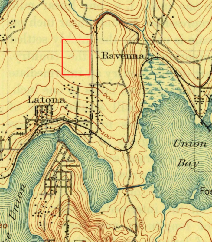
A section of the 1908 USGS survey of Seattle, with a red square added to highlight the area around Block 63.
While I couldn’t find any specific records, a 2002 survey report done by the City of Seattle examines the history of the University District. The area where Block 63 sits “...was once thickly forested… The topography of the area was similar to the present, with a gentle slope to the southwest (west of 15th Ave)... No extensive regrading has been done in the University District” (Tobin).
In addition, early topographical maps show no major streams running near Block 63, but from a 1908 map by the United States Geological Survey (USGS), 63 is on a plateau near the top of a hill from North to South, but angles up noticeably from West to East. From my recent visit, I saw the topography cresting midway through the block, as there is a peak in the alley which then drops off noticeably between the alley and 11th Ave.
Block 63, much like many other blocks in Seattle, is a part of an addition made by a land speculator, who then sold plots to live on. In this case, that owner was Herman C. Pettit, who moved to Seattle in 1889, and by 1902 had his own company making land additions, including Pettit’s University Addition, which spans most of the 12 blocks between 45th and 55th Streets, and 10th and Brooklyn Avenues. The Baist Map of 1912 shows less than a majority of the plots have been used (in contrast to the 1908 map, which shows no development North of 45th Street), but the block was likely fully developed before the apartments and YMCA was developed in the 1950’s and 60’s.
After taking another look around my block, I found no major signs of the the natural environment exerting influence on the current urbanized landscape. There are few major trees which could have predated the block, so it is most likely that the area was clearcut, and then the trees were added. There is a consistent slope in the topography that can be seen in the parking lots, but most of the apartment buildings have basements that cut into and have dug up the natural landscape on the 11th Ave side, while the flatter 12th Ave side is mostly intact.
Overall, Block 63 is a fairly simple block: on high ground, little incline, loggable, and thus easy to develop as a block for land sales. Despite work done by current apartment buildings to dig into the land for basements, there is little to no visible regrade work, and the land was developed quickly, comparing the vast differences in development between 1908 and 1912.
Works Cited
Bagley, Clarence. “History of Seattle from the Earliest Settlement to the Present Time.” History of Seattle from the Earliest Settlement to the Present Time (Online), vol. 3, The S.J. Clarke Publishing Co., Chicago, IL, 1916, pp. 81.
Tobin, Caroline, and Sarah E. Sodt. University District Historic Survey Report. Seattle, WA, The Dept. of Neighborhoods, 2002.


