Site Report 2
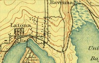
A map of Seattle dating back to 1894, zoomed in for a better view of the U District and the surrounding area. University District (Seattle, WA). Created 1894 by A.H. Thompson & R.H. McKee.
I was unfortunately unable to find any maps or images of Block 8 in particular before or during its development from a natural environment to a city one. However, based on the maps and data that were available, I found that the U District, contrary to much of the rest of Seattle, is just as hilly today as it was in its early days. The map I found from the late 1800s places the area near Block 8 at approximately 200ft elevation, which is pretty accurate to the actual elevation of 196ft (US Geological Survey, 1894). The elevation rises quite rapidly from both Lake Union and Union Bay, rising to that 200ft in less than half a mile in some areas (US Geological Survey, 1894). This may explain why most of the older buildings in this area are somewhat smaller and shorter, as taller buildings would be more difficult to keep stable in such conditions. It also explains the types of businesses that flourished here. The story of rolling logs down Skid Row may seem a novelty today, but back then it truly was what made the lumber business easier and more successful. In addition to the hills, East of the Block and the rest of the University District, there appears to be a swamp or marshland. All of the planned roads and railroads curve around this swamp, which makes sense considering the technology and construction of the time (US Geological Survey, 1894).
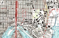
A map of Seattle dating to 1983, zoomed in to view the U District and the surrounding area. University District (Seattle, WA). Created 1983 by the United States Geological Survey & National Ocean Survey.
Over time, the hills seem to have remained relatively untouched, unlike in other cities. The more modern map I found marked Block 8 at around 55m, or about 180ft (US Geological Survey, 1983). This is a little off from the actual 196ft (about 60m), but still close. The marsh, however, is now completely gone and replaced by the University Village. In addition, some of the area that used to be part of Union Bay has been filled (US Geological Survey, 1983).
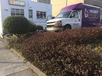
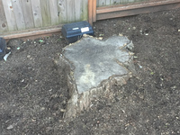
Currently on the site, there is not much nature to be seen. Most, if not all, of the plants present are used to decorate the University Bookstore or the Malloy Apartments. These include several rhododendrons planted alongside the sidewalk outside of the Bookstore’s parking lot. However, there is one tree planted on the corner of the block that may have been there originally there. The corner and the lot around it are built in order to accommodate this tree, rather than the tree being planted in a place deemed suitable. In addition, there is evidence of a tree near the apartments that has been cut down. Other than this, there are some bushes and other plants in and around the lot, but they again appear to have been put there purposefully as decoration, rather than originally and naturally there.
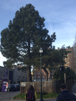
A photo of the corner of 15th & 43rd, focusing on the tree planted there. University District (Seattle, WA). Taken on February 2, 2017 by Esko, Garrett.
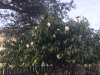
A photograph of one of the rhododendron plants outside the University Bookstore, with a tree in the background. University Distrcit (Seattle, WA). Taken on February 2, 2017 by Esko, Garrett.

