Site Report 4
Most of the development and planning in Block 8 has centered around 43rd St., the Southernmost edge of the block. Multiple documents have references to this specific street, and have planned or acknowledged changes to its infrastructure. One major change that has already been made is the addition of an East-West pedestrian crosswalk along 43rd and across 15th (University Community Urban Center Association and City of Seattle's Interdepartmental Review and Response Team [23]). This was added in order to improve connections between the Ave and the University of Washington campus. In addition, the crosswalk serves as a test case for potential future crosswalks along other streets (University Community Urban Center Association and City of Seattle's Interdepartmental Review and Response Team [22]). Other changers have been made to 15th Ave., such as improved lighting, traffic signals, sidewalks, and pavement. The Northernmost border of these changes happens to be 45th St., the top border of Block 8 (University Community Urban Center Association and City of Seattle's Interdepartmental Review and Response Team [23]).
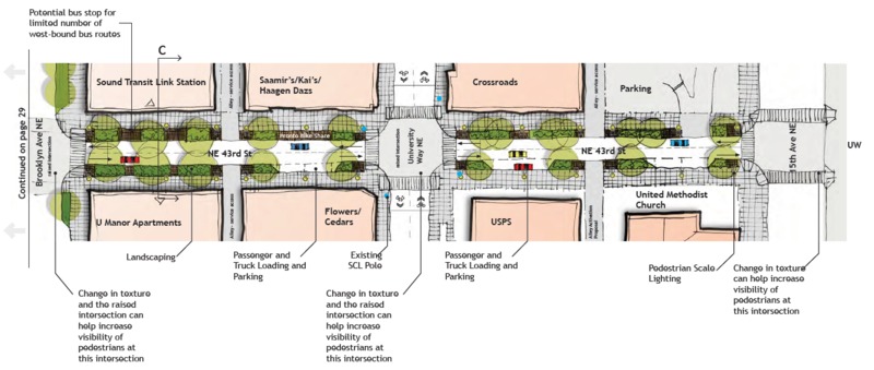
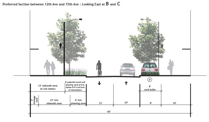
In terms of future changes, the city has planned to continue to improve conditions on 45th and 43rd streets., as they are heavy in both pedestrian and bus traffic. These improvements include more and better pedestrian lighting and crosswalks (University Community Urban Center Association and City of Seattle's Interdepartmental Review and Response Team [22]). Also of note is the landscaping plans. As mentioned in Site Report 2, there is not much greenery on Block 8, whether natural or planted. However, the city has plans from 2015 with the goal of, among other things mentioned earlier, increasing landscaping and greenery on 43rd St (Seattle Department of Planning and Development and Seattle Department of Transportation [27]). The plans call this “park like landscaping,” and appear to detail several small patches of grass and plants along both sides of the street (Seattle Department of Planning and Development and Seattle Department of Transportation [27]). While this has not yet been implemented, the prevalence of these plans in two separate documents – both the UD Green Streets Concept and the UD Parks Plan – shows a desire across multiple groups of people for this landscaping to be added.
In general, the U District has been a place of small businesses that cater to the needs of the students. While there are some larger shops and businesses, the vast majority of the shops are much smaller (Downtown Works, LLC [8]). Block 8 displays this mix, with the large and dominating University Bookstore and the chain Bartell Drugs, complimented by the smaller Import Shop and Crossroads Trading. As such, future development should probably focus on developing the smaller businesses, allowing new ones to come in as old ones leave or grow out of the space, and creating an environment where they can survive and thrive without competition from larger chain stores. That said, the primary focus of the U District should be the students. While the Bookstore does a good job at catering to them, many of the other businesses and buildings on this block are rarely used by students, showing a need to reorganize and reestablish certain businesses.
Works Cited
Downtown Works, LLC. U-District Retail Study & Strategy. University District Partnership, Sept. 2014.
"Historical Maps." Legacy Washington, Washington Secretary of State, www.sos.wa.gov/legacy/maps/maps.aspx. Accessed 17 Feb. 2017.
"Our History." University Book Store, 2017, www.bookstore.washington.edu/_about_us/about_us.taf?page=history. Accessed 17 Feb. 2017.
Pulkkinen, Levi. "Seattle's University District through the years." Seattle PI, 29 Mar. 2015, www.seattlepi.com/local/article/Seattle-s-University-District-through-the-years-6164332.php#photo-7729215. Accessed 17 Feb. 2017.
Seattle Department of Planning and Development, and Seattle Department of Transportation. U District Green Streets Concept Plan. Seattle Department of Planning and Development, 2015.
"Seattle Municipal Archives Map Index." Office of the City Clerk, seattle.gov, clerk.ci.seattle.wa.us/~public/maps1.htm. Accessed 17 Feb. 2017.
University Community Urban Center Association, and City of Seattle's Interdepartmental Review and Response Team. University Community Urban Center Approval and Adoption Matrix. Compiled by Strategic Planning Office, edited by City Council Central Staff, University Community Urban Center Association, 11 Nov. 1998.
US Geological Survey. 1983 Map of Seattle, Zoomed in to U District Area. US Geological Survey, 1983. Seattle Municipal Archives Map Index, US Geological Survey, historicalmaps.arcgis.com/usgs/. Accessed 3 Feb. 2017. Map.
US Geological Survey. 1894 Map of Seattle, Zoomed in to U District Area. US Geological Survey, 1894. Seattle Municipal Archives Map Index, US Geological Survey, historicalmaps.arcgis.com/usgs/. Accessed 3 Feb. 2017. Map.


