Site Report 3
When land development originally began in the University District in the late 19th century, Brooklyn Avenue was intended to be the main commercial avenue, the street that was the center of the neighborhood (Tobin, Sodt 9). Early maps of the neighborhood show this too. In the 1894 map entitled “McKee’s Correct Road Map of Seattle and Vicinity,” Brooklyn Avenue is depicted as the primary site of development, having multiple buildings on it already, while the avenue with the streetcar railway, University Way, is nearly empty of buildings. However, come 1920, in Kroll’s Real Estate Atlas, it is evident that University Way (listed as 14th Ave NE in the Atlas) has become the commercial center of the neighborhood, while Brooklyn’s development is slower. This is the case because of the mere fact of the streetcar railway being placed on the Ave, which gave the Ave a much higher amount of traffic and made it the commercial hub that Brooklyn was originally intended to be. Instead, Brooklyn, and the West Side of Brooklyn especially, which Block 22 lies on, would become a residential Avenue. The Zoning Map of 1947 displays that the City’s planners had hopes of making Brooklyn Ave, between 41st and 42nd Streets, a block of businesses and commercial enterprises. But the Levere Apartment building, for instance, had already been constructed (1927). This residential direction is the direction the block would take. The 1936 Aerial Photograph of the block shows a block of nearly entirely residences, and by 1960, the entire East side of the block, on Brooklyn Ave, would be occupied by apartment buildings that stand there today. These buildings often housed the increasing student population because of their relatively affordable rent and proximity to campus. One newspaper listing from 1955 lists a two-bedroom apartment in the Levere for just $90 a month, equivalent to about $800 today. As the 1973 Zoning Map shows, the entire block had been assigned “Multiple Residence High Density,” depicting that the city had shifted away from attempting to make this block commercial to an attempt at providing a space for housing for the increasing student population.
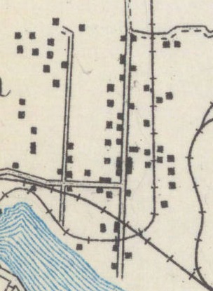
Shown here is a selection of the 1894 map titled "McKee's Correct Road Map of Seattle and Vicinity." It is interesting because it shows that at this point in the neighborhood's history, Brooklyn was one of the main streets and had the largest cluster of buildings, though the Railway on University Way had just been built.
Seattle Municipal Archives. 1894.
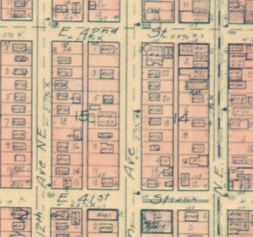
Here is a selection from the 1920 edition of Kroll's Real Estate. This selection is interesting because it shows the shift that has occured in the two adjacent blocks since 1894. The majority of development had occurred on the University Way block, while the block to the West of Brooklyn (Block 22) developed slower. This is so because University Way had a railway, and therefore much more traffic. This difference in infrastructure was instrumental to Block 22's becoming a residential block. University of Washington Libraries, Special Collections. 1920.
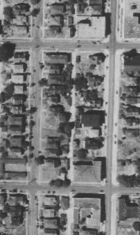
This 1936 Aerial Photo of my block shows that the block had, at this point, already become mostly residential, given the architectural styles of the buildings shown. University District (Seattle). King County DOT - Road Services. 1936.
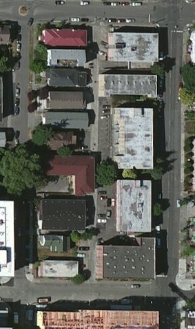
This is the current aerial image of Block 22, showing the block to be entirely residential and similar in layout to the 1936 image, especially along the West side of the block. University District (Seattle). Google Earth. 2017.
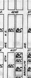
A selection from the 1947 Seattle Zoning Map, showing the City's plans for the block. The city wanted, at this time, to see the East side of the block develop with businesses and commercial enterprises, while having the part of the block West of the alley be residences. Seattle Municipal Archives. 1947.
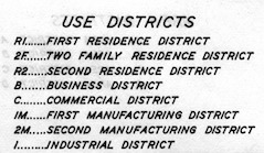
Key for the 1947 Zoning Maps. Seattle Municipal Archives. 1947.
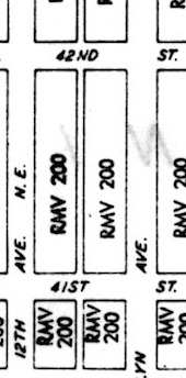
Shown here is a selection of the 1973 Zoning Maps, which display that the city was no longer interested in turning my block, especially on the Brooklyn Ave side, into a commercial block. The city had turned its attention to the fact of its needing residences with the University's burgeoning student population. RMV 200 means "Multiple Residence High Density." Seattle Municipal Archives. 1973.
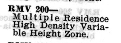
Key for the 1973 Seattle Zoning Maps. Seattle Municipal Archives. 1973.

A 1955 listing for a two-bedroom apartment at the Levere on my block. $90 per month is equivalent to about $800 a month now. Living here would have been reasonably affordable for students (at what would be about $400 per month now), suggesting that much of the housing on this block was directed towards students, given the increasing student population at the University and my block's extremely close proximity to Campus. Seattle Daily Times. America's Historical Newspapers. 14-10-1955.
Works Cited
