Site Report #4: THE PAST AND FUTURE OF U DISTRICT

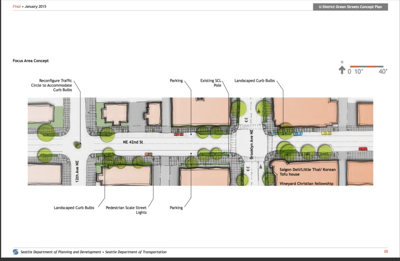
Visual map of 42nd and Brooklyn and the ideal additions to make the street pedestrian friendly. Published by Seattle Department of Planning and Development/Seattle Department of Transportation, published 2015.

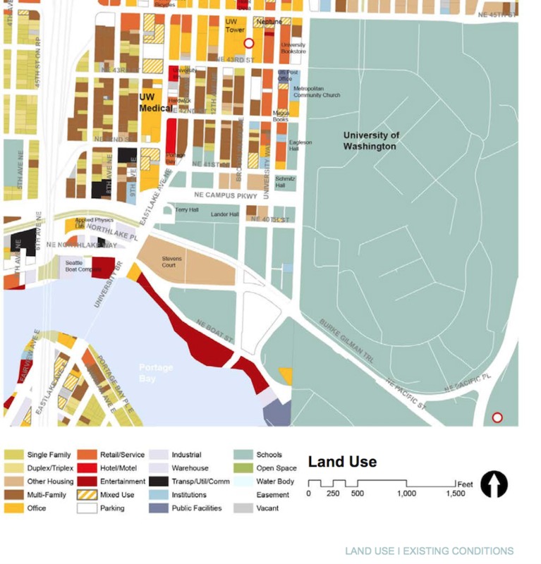
Map from 2012 that shows the land usage of my block, which was largely multi-family homes, retail, and offices at the time. Published by City of Seattle, Created by Department of Planning and Development, published, published June 2012.
Currently, my block is home to a multitude of retail and restaurant stores, as well as limited amounts of housing. As I discussed in my previous site report there is some major construction occurring on the Brooklyn side in order to tear down the old housing and replace it with a new student housing unit. According to plans from the U District Green Streets Concept Plan from January of 2015, there was a plan to clear a larger sidewalk path of travel on the 42nd street side of the block, as well as introduce landscaping through mid-block curb bulbs. The document recognizes that 42nd is mostly residential- which is still applicable in 2017 – and it recognizes 42nd as a well used pedestrian entrance into the UW campus. This pedestrian-friendly plan complements the historical usage of the block which has always largely been foot traffic. Taking a look at a street-view comparison on Google maps between the years of 2015 and 2017, it looks like the plan has not taken action yet, although construction on Brooklyn for the student housing seem to be interrupting some of the plans to build the curb bulbs on the intersection of 42nd and Brooklyn.( U District Green Plan 31). Taking a look at the history of my block, it seems to have always conformed to the needs of the community around it. The church began when there was a need for religious meeting space; a student club started when the UW began to grow in population; the railway stopped on this street due to the large amount of commuting students. Since the community currently consists of students from the UW going to the Ave for food or other services, future developers should consider this and realize that foot traffic will continuously be made up of students on the go.
Taking a look at the land use map from 2012 from the University District Urban Design Framework document, it shows that just 5 years ago the Brooklyn side of my block was used largely for multi-family and single-family housing. The University Ave side was used for retail and office space. While the retail aspect of this remains true, the Brooklyn side is currently largely under construction and the multi-family housing no longer exists as it is being converted to student housing (Urban Design Concept, 22). There really isn’t room to wonder what a student-centered University District would look like in the future in terms of my block as it seems to already be converting to exactly that. The multi-family housing will disappear and will be changed completely to student housing. The restaurants and retail stores will most likely stay for the hungry college students but the last of the office buildings and churches may disappear or relocate as they are not a central necessity to student life. The sidewalk that is under construction will have to reappear again as foot traffic will most likely continue to increase.
WORKS CITED:
Dorpat, Paul. "Now & Then: University Station," The Seattle Times, Northwest Magazine, July 30, 1995.
Dorpat, Paul. "Seattle's University District - a Slideshow of its Early History." HistoryLink. The Free Encyclopedia of Washington State History, 1 Jan. 2000. Web. 15 Mar. 2017.
Menges, Gary. "VIII. The University District." VIII. The University District - UW Libraries. University of Washington Special Collections, n.d. Web. 15 Mar. 2017.
Nielsen, Roy G. UniverCity: the city within city, the story of the University District. Seattle: U Lions Foundation, 1986. PDF.
Pulkkinen , Levi. "Seattle's University District through the years." Seattlepi.com. Hearst Seattle Media, 29 Mar. 2015. Web. 15 Mar. 2017.
Seattle Department of Planning and Development. U District Green Streets Concept Plan. Rep. Seattle: Seattle Department of Transportation and Seattle Department of Planning and Development, 2015. PDF.
"Seattle Municipal Street Railway Photograph Collection, 1913-1940." Archives West: Seattle Municipal Street Railway Photograph Collection, 1913-1940. Orbis Cascade Alliance, 2005. Web. 15 Mar. 2017.
Tate, Cassandra. "Seattle Repertory Playhouse opens new theater on February 2, 1930." HistoryLink. The Free Encyclopedia of Washington State History, 21 Feb. 2002. Web. 15 Mar. 2017.
The Department of Planning and Development. University District Urban Design Framework. Rep. City of Seattle: Department of Planning and Development, 2012. PDF.
