Site Report 4
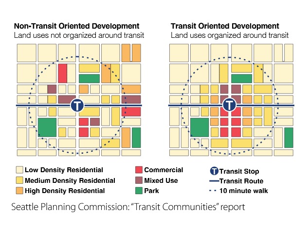
Transit Community Plan - UD Urban Design Final Recommendations 2016
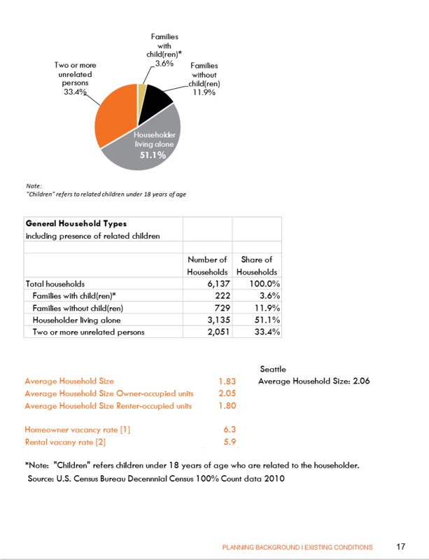
Household Types - UD history and existing conditions report in 2014
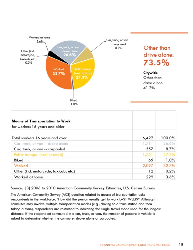
Transportation Methods - UD history and existing conditions report in 2014
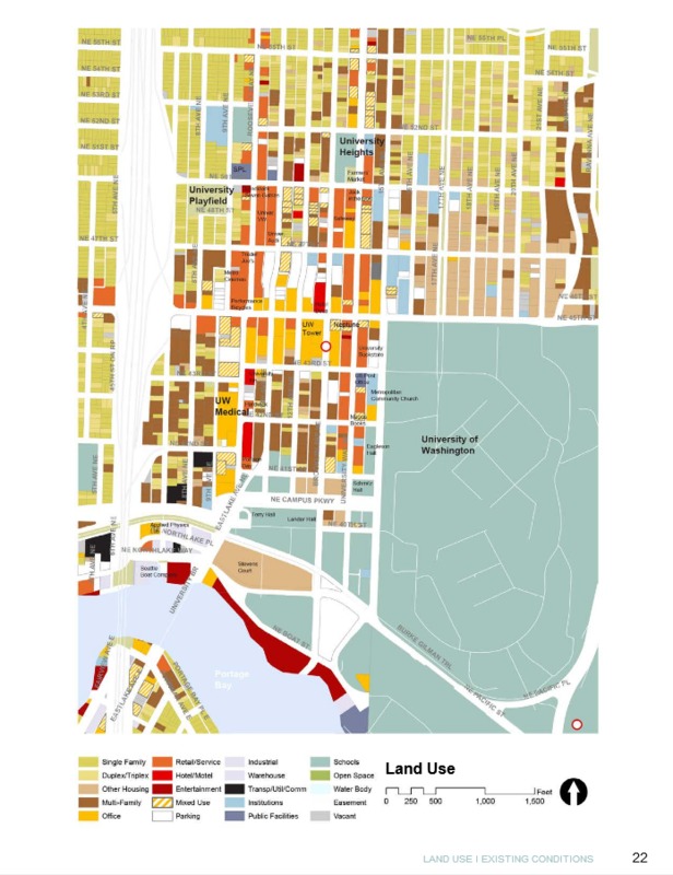
Land Use - UD history and existing conditions report in 2014
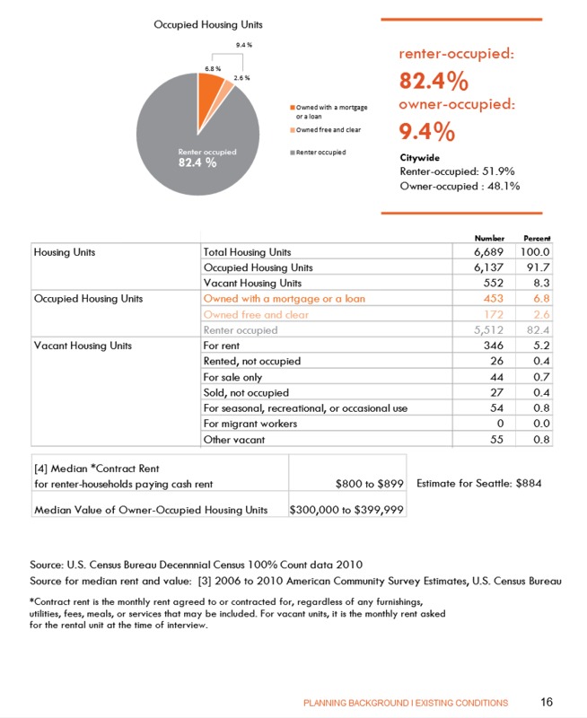
Occupied Housing Units - UD history and existing conditions report in 2014
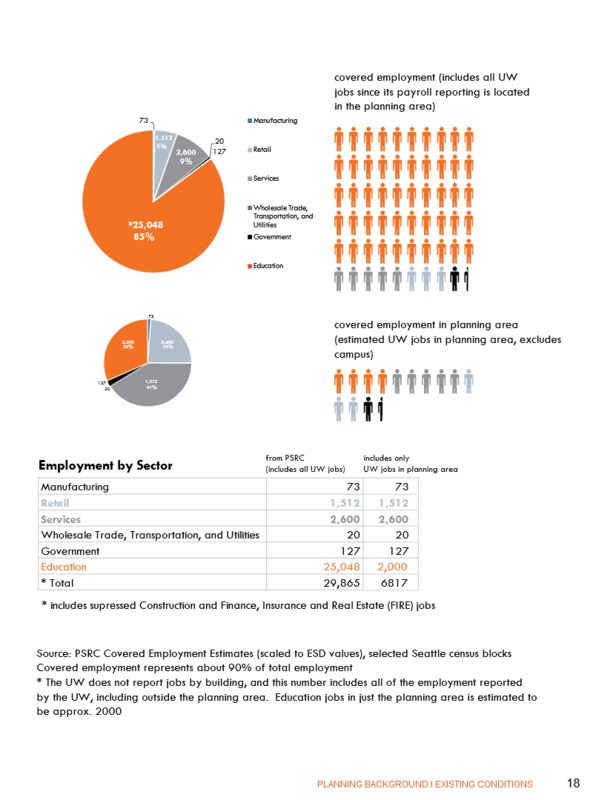
Demographic Occupation - UD history and existing conditions report in 2014
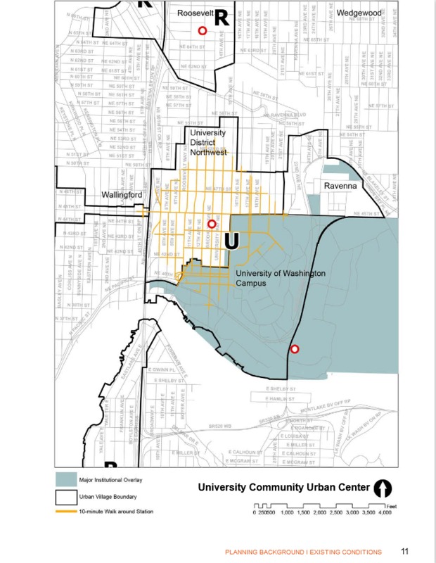
Walking Distance from Station - UD history and existing conditions report in 2014
THE PAST AND FUTURE OF U DISTRICT
------
Today’s neighborhood on block 72 is nestled comfortably away from the central hub of commercial buildings as can be seen in the land use map. Nearly all of the houses on this block are rooming houses for students or split into units and rented out as shared apartments. Along Brooklyn you can also see the spreading acquisition of land for housing by the University from the University Court Apartments.
Historically, this region of the district has been focused on providing housing to the students and faculty of the UW and in providing a community for the University. This can be seen with the booming movement in housing development almost immediately after the UW moved to the area (late 1800’s and early 1900’s) and the installation of the streetcar on Brooklyn meant to accommodate those who lived further from campus. Today, according to the UD history and existing conditions report in 2014, 82.4% of households in the U District are renter occupied, giving a nod to the 85% of people who are in the education sector.
Understanding the demography of the U District and the needs and wants of the community and its future, the City of Seattle has made a conscious decision to redefine and improve transportation in the area in the hopes that it will encourage a diversity of housing opportunities, support a thriving commercial community, and implement environmentally sustainable infrastructure. This decision comes largely in the form of the new Northgate light rail station being built on 43rd and Brooklyn Avenue NE which is projected to be open in 2021.
This plan for another large transit site compliments the historical usage of block 72 (an upgrade of the streetcar and has wider cross-city reach) which is meant to offer housing with close proximity to the UW for students. Its location will be a 10 minute walk from block 72, but it would ultimately save students the long bus rides down to the next station, simplify their travel needs around the city, and be specifically beneficial to students who need to commute to SeaTac during breaks.
Because of its close proximity to a future light rail station, block 72 is most likely going to turn more commercially and university owned (new apartment buildings). Housing taxes and rent will most likely rise because of increase in land value which is likely to drive out homeowners that cannot afford to continue renting their rooms at their current prices. The improved transportation will also encourage outward spread of the commercial nexus of the district, further pushing renters outwards. Average commuting distance for students, for example, has increased from 6.87 in 2008 miles to 8.28 miles in 2010 (UD history and existing conditions report in 2014, 41). The immediate areas surrounding the station will have to be outfitted to be a transit community that is heavily focused on pedestrian and bike traffic which might call for more biking lanes than the single one found along 12th.
A student centered U District may look to have better methods of transportation between students who live further away and campus, or to even offer more housing and offset the cost of living by adding more rooms to buildings. Ultimately, the goal would be to lower to cost of housing and commercial items in the district and make movement easier for students without a car or bike.
----------------------------------------------------------
WORKS CITED
------