Site Report 3: Audio Tour

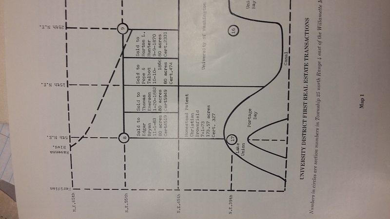
A map detailing the first property owners of the U-District including Edgar Bryan and Thomas Emerson who were the first owners of the land of what is now Block 54 between Roosevelt Way and 11th Ave NE, and 47th and 50th St. NE. (1986) Courtesy of UW Special Collections, "UniverCity" by Roy G. Nielsen. Print.

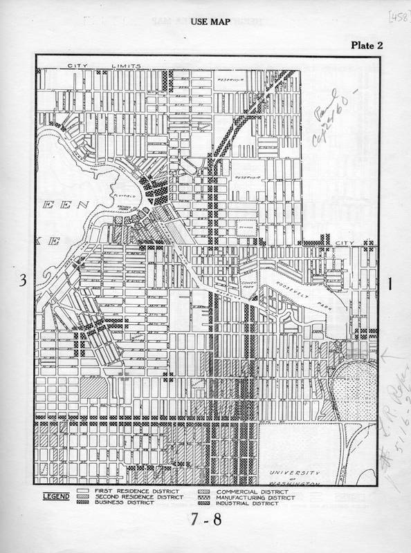
This Seattle City Zoning Map from 1923 shows that the block was hime to Second Residence housing at this time. This is before the Volkswagen/Audi dealerships were built on the property in the 1950s. (1923) Courtesy of Seattle Municipal Archives. Map.

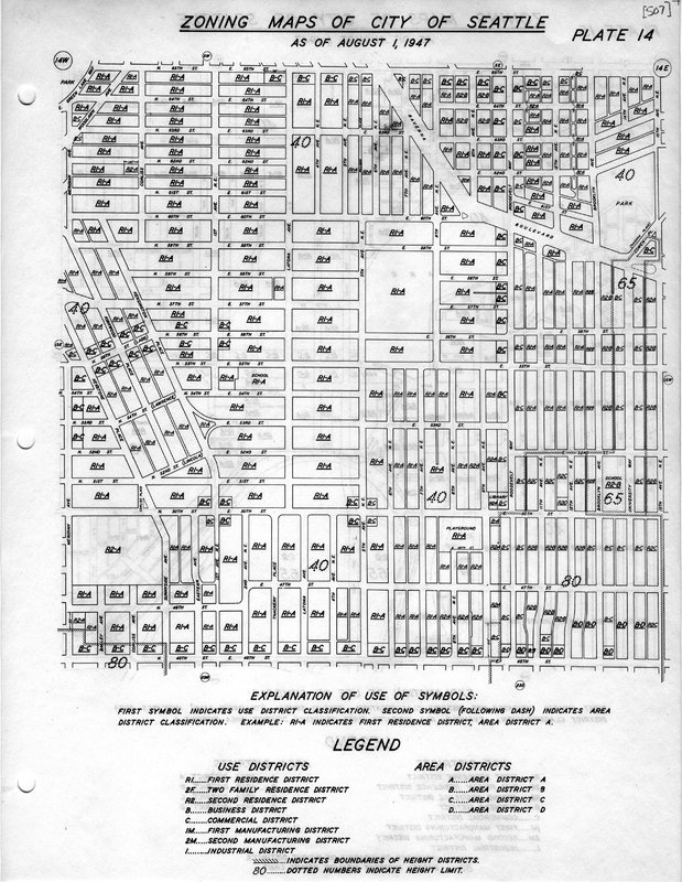
By 1947, the block of 10th Ave had been recently renamed Roosevelt Way in honor of recently deceased president Theodore Roosevelt in 1927. In 1947, the block between Roosevelt Way NE and 11th Avenue NE had developed into a business/ commercial area in addition to residence housing on 11th Ave. (1947) Courtesy of Seattle Municipal Archives. Map.

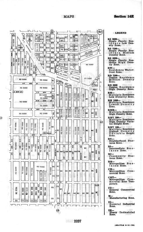
As shown in this August 1973 Zoning map of the Univeristy district, the block is labeled as a BC (Community Business Zone) where the Volkswagen and Audi dealerships would hve been located, while the southeast portion of the block is listed as a CG (General Commercial Zone) where the current parking lot would have still been then. (1973) Courtesy of Seattle Municipal Archives. Map.
https://drive.google.com/file/d/0B7m_Vz7E4X95eTd0S2syYU53Sjg/view?usp=sharing
Following the 1895 move of the University of Washington to its current location in the University District, came the gradual influx of residents to the area in the following decades in great numbers. Infrastructure, residences, businesses all began to develop in a staggering way with the growth of the University and the population of the surrounding neighborhoods including block 54 between Roosevelt Way NE and 11th Ave NE and 47th and 50th St NE. The earliest property owners on the block besides the Duwamish Indians who originally settled in the area, were Edgar Bryan (11/1/1883) and Thomas Emerson (1/20/1882), who each owned 80 acres apiece north of NE 45th and south of NE 55th St. from 8th Ave NE to 15th Ave NE[1] (Pg. 2). There is no other recorded history of these two names, or what they did with their property. However, by 1884 each person’s property was either sold or modified as streets were plotted and implemented for this block as indicated by a Sanborn Fire Insurance Map of the block at the time[2] (Sanborn Fire Maps). It is likely Emerson and Bryan purchased the land for speculation. After the discovery of coal in Seattle, the construction of a railroad in the University District was integral to transporting product and people north, allowing for development to occur in the region. In the early 20th century in the U-District, streets were developed and houses built – many of which are still constructed to the very day. Coinciding with the Alaska-Yukon-Pacific Exposition in 1909, the area became more densely populated at the turn of the century. One such block – block 54, between what was formally known as 10th Avenue NE (renamed Roosevelt Way in 1927 in honor of Theodore Roosevelt’s passing), and 11th Avenue NE from 47th Street NE to 50th street NE, over the course of the first half of the 20th century developed from a suburban neighborhood to a more commercial zone.
As evidenced from a Seattle City Zoning Map of the U-District from 1947, the block began to develop from strictly a residential block to a more business-oriented one with many car dealerships emerging by 1928[3] (Seattle Zoning Map 1947). If one were to look into a 1939 Seattle City directory, there was a Cass Pontiac used car dealership on 4718 Roosevelt Way NE, a Big Bear grocery store on the northwest corner of Roosevelt, a residence belonging to Effie Gibson on the northeast corner on 4750 11th Ave NE, and another used car dealership Hirsch Motors Used Cars also next door[4] (Seattle City Directory). Dating back to the 1920’s this block has had an immense history of automotive businesses which has lasted until this day. Being very close to the Interstate-5 north-south highway, and being a prominent area of business activity since early days of development, can help explain the block’s consistency in the automotive business. In 1955 Bob Will, a former member of the famous 1948 UW Olympic rowing team invested in a Volkswagen dealership and the University Volkswagen site was built on its current location and has remained there. Freeway Motors Inc. or known now as Audi Seattle and University Volkswagen is a joint dealership adjacent to one another on the block, owned by Freeway Motors Inc. and has been a fixture in the neighborhood since the late 1950s[5] (University Audi website).
The residences surrounding the block in the early 1920s were part of a neighborhood solely filled with houses and other forms of accommodation along 11th Ave NE. Over time however, the block developed to incorporate businesses and more living spaces and by 1973 houses began to decrease in numbers on the block. For example, apartments which have remained on the block on 4718 11th Ave NE since 1939 at least, when residents Lillian Kean, Blanche Jackson, Lawrence Jenner, Walter Kean, and Don Williamson lived there[6] (Seattle City Directory). These apartments were most likely reconstructed into their modern form are still in the same location as they were in 1939 facing opposite the Audi Dealership on 11th, meanwhile there is currently construction taking place for new apartment complexes on the northwest corner of the block towards Roosevelt Way. This area has seen more students come into the area over the years, as it is so close to the UW campus, so it is still a relatively youthful area when compared to the early 20th century. What was once a rural area, has developed gradually into a residential neighborhood in the early 20th Century with families, students, and others living there, eventually fostered itself into one of the central business spots in the University District by the 1950s and continues to be today.
[1] Nielsen, Roy G. UniverCity: A City within a City, the Story of the University District in Seattle. Seattle, WA: U Lions Foundation, 1986. Print.
[2] Microform. Sanborn Fire Insurance Maps 1884, 1904-1905 (1884, 1904-1905): reel 10.
[3] Seattle City Zoning Map, 1947. City Planning Commission of Seattle. Seattle Municipal Archives – Map Collection.
[4] Seattle City Directory. 1939. University of Washington Special Collections, Seattle, WA. 15 March, 2017.
[5] Audi Seattle. Dealer.Com, n.d. Web. 15 Mar. 2017. <http://www.audiseattle.com/dealership/about.htm >.
[6] Seattle City Directory. 1939. Pg. Unknown.
