Site Report 4

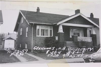
As you can see in the very right corner, the sidewalks of my block have always had a green planting strip to act as a barrier from the road since its first development. Photograph taken August 4th, 1925. King County Parcel Viewer. Photo taken August 8th, 1925. King County Parcel Viewer.

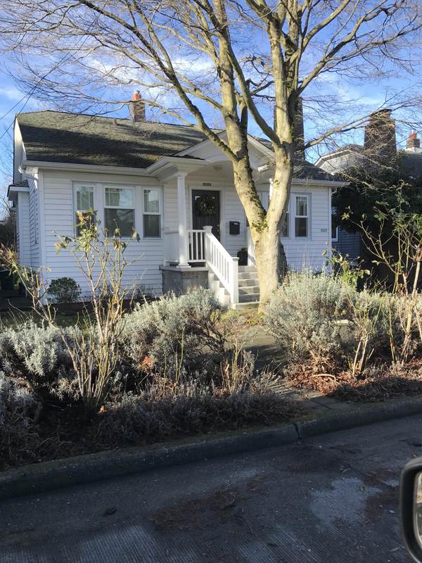
This image shows the over grown planting strip that sits outside this original 1920's house. Other areas of the planting strip do not show the same trend and instead have unkept patches of grass. Photo taken by author 01/23/17.

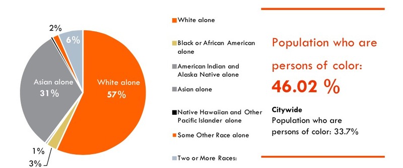
This image describes the current percentages of different ethnicities in the University District. As you can see, the population is currently dominated by white residents and 31% of Asian residents with a low diversity of people of color. University District Urban Design Framework- Existing Conditions Report. A Report by the Department of Planning and Development: Draft June 2012.
My block currently resides in the “Single Family Zone” according to the city planning documents such as the UD Residential Market Analysis of 2013 (City). It sits on the left side of Roosevelt Way NE, barely missing the new development zone as it cuts off directly before 9th Avenue. However, this does not mean my block will not be affected by the renovations and sky rises that will be developed around it. My block today has wide sidewalks with a barrier of green space for distance from the road and to give the neighborhood a more attractive and green look. However, this barrier of planting space between the road and the sidewalk has been there since original development. You can see this between the current photo and the photo from the beginning of my block's residential history. Although it gives it a certain charm, it is easy to tell that these amenities might need to be upgraded. This is because of the noticeable inconsistencies between wild growth and worn out grass on different patches of the planting barrier as well as cracked and unkept sidewalks. The city may need to make a few improvements in this neighborhood soon in order to keep up with the new and fast paced renovations that will soon greatly influence my block.
The City of Seattle is currently planning many new upgrades to surrounding areas in order to make it a more ideal urban space that is capable of growing into a small city which will have a strong youthful presence. New developments such as skyscrapers and apartment buildings are meant to create affordable housing and a more diverse community. The planners are aiming to give the U District life they always knew it contained and refresh it through a variety of means. Although my block will not be directly involved in the new developments, it will definitely be affected. The new development such as the anticipated skyscrapers and apartment buildings will be centered in the University District due to multiple factors.
First, an entire new landscape of retail will be centered in the urban sprawl with more consistent businesses as well as the design of the retail space. These improvements will be beneficial due to the wealthier income demographics in all the neighborhoods surrounding the center, included my block. Skyscrapers/apartment buildings will also add to a massive influx of residents in this area. Demographics show that in 2010 around 14,200 people lived in the U District and over 75% of them were of the ages 18-29. This data is from the UD History and Existing Conditions report from 2014 (The Department). Therefore the addition of massive amounts of available and affordable housing will create a booming, unique and fresh community with the draw of the University of Washington next door.
The developers want to add onto this wealth of youthful activity with community centers for concerts and other community events. The urban design is focusing on a green scape vision that will be centered on the pedestrian and a more visually appealing urban space according to the UD Green Streets Concept Plan of 2015 (Seattle Department). This is due to the development being centered around the upcoming Link station that will appear in the year 2021 on Brooklyn Avenue NE and NE 45th Street. An entire renovation of Brooklyn Avenue will be completed in order to update the area and make transportation easier to the station via bike and walking. This will be done through new bike lanes, and beautifying sidewalks while also making them safer. Much of these plans have yet to be implemented, but will soon begin due to the completion of the new Light Rail Station in just four years.
Much of these new developments and design were carefully selected from many considerations of the history in this area. Ever since its development, the University District has always been regarded as an urban city with a high potential for growth. For years, developers and local leaders have been brainstorming the best way for their community to develop into the powerful urban city they always knew was possible. With the close proximity to the University of Washington, the U District has always had the strong influence of youth culture. Therefore, now with big plans to overhaul the area, it is easy to see how the developer’s visions are based off of a modern and young community.
The skyscraper apartment buildings, that will pop up in the 10 minute walking zone around the link station, are designed to produce more single occupancy living areas instead of homes for growing families. Thus the developers are merely trying to enhance and develop around the University Districts prominent demographics of young people. Therefore we must look at what kind of youthful community we want to develop.
I think the developers might agree the importance of making the University District more diverse so that it can be richer in culture. Hopefully through the creation of affordable housing, the current demographics of the population only being 46.02% people of color, may change to become more diverse in the future.
This rapid urban development follows the trend of accomodation of public transportation, which is a big change from the accomodation of the car due to the rapid expansion of suburbs in the 1960's. However, now the focus is cleaning up cities and making them a place of development and innovation where middle class people can reside.
Therefore if we fully consider all the possibilities and consequences of this rapid urban expansion, the University District in the future will be able to live up to its highest potential. And through this, developers may be able to achieve what local leaders throughout history have always envisioned for this city within a city since its first development.
Works Cited:
